EENS 3050

Natural Disasters

Tulane University

Prof. Stephen A. Nelson

River Systems & Causes of Flooding


Flooding

Throughout history humans have found it desirable to construct cities along streams.  Streams are sources of water for consumption, agriculture, and industry. Streams provide transportation routes, energy, and a means of disposal of wastes. Stream valleys offer a relatively flat area for construction. But, human populations that live along streams also have the disadvantage that the flow of water in streams is never constant. High amounts of water flowing in streams often leads to flooding, and flooding is one of the more common and costly types of natural disasters.

A flood results when a stream runs out of its confines and submerges surrounding areas.

  • In less developed countries, humans are particularly sensitive to flood casualties because of high population density, absence of zoning regulations, lack of flood control, and lack of emergency response infrastructure and early warning systems.

  • Bangladesh is one of the most susceptible countries to flood disasters.  About one half of the land area in Bangladesh is at an elevation of less than 8 meters above sea level.  Up to 30% of the country has been covered with flood waters.  In 1991 more 200,000 deaths resulted from flooding and associated tropical cyclones.

  • In industrialized countries the loss of life is usually lower because of flood control structures, zoning regulations that prevent the habitation of seriously vulnerable lands, and emergency preparedness.  Still, property damage and disruption of life takes a great toll, and despite flood control structures and land use planning, floods still do occur. 

    Causes of Flooding

From a geological perspective, floods are a natural consequence of stream flow in a continually changing environment.  Floods have been occurring throughout Earth history, and are expected so long as the water cycle continues to run.  Streams receive most of their water input from precipitation, and the amount of precipitation falling in any given drainage basin varies from day to day, year to year, and century to century.

The Role of Precipitation

Weather patterns determine the amount and location of rain and snowfall. Unfortunately the amount and time over which precipitation occurs is not constant for any given area.  Overall, the water cycle is a balanced system.  Water flowing into one part of the cycle (like streams) is balanced by water flowing back to the ocean. But sometimes the amount flowing in to one area is greater than the capacity of the system to hold it within natural confines. The result is a flood. Combinations of factors along with exceptional precipitation can also lead to flooding.  For example, heavy snow melts, water saturated ground, unusually high tides, and drainage modifications when combined with heavy rain can lead to flooding.

Coastal Flooding

Areas along coastlines become subject to flooding as a result of tsunamis, hurricanes (cyclonic storms), and unusually high tides.  In addition, long term processes like subsidence and rising sea level as a result of global warming can lead to the encroachment of the sea on to the land. 

Dam & Levee Failures

Dams occur as both natural and human constructed features.  Natural dams are created by volcanic events (lava flows and pyroclastic flows), landslides, or blockage by ice.  Human constructed dams are built for water storage, generation of electrical power, and flood control.  All types of dams may fail with the sudden release of water into the downstream drainage.  Spectacular and devastating examples of dam failures include that resulting in flooding downstream include:

  • The St. Francis Dam, near Saugus, California, failed in 1929 killing 450 people.

  • The Johnstown, Pennsylvania dam, built of earthen material (soil and rock) collapsed after a period of heavy rainfall in 1889.  2,200 people were killed by the flood.

  • The Vaiont Dam in Italy (discussed in a previous lecture on mass-wasting) did not fail in 1963, but the landslides that moved into the reservoir behind the dam caused water to overtop the dam killing over 3,000 people.

As we have seen during Hurricane Katrina in New Orleans, levee systems designed to prevent flooding can also fail and lead to catastrophic flooding and loss of life. 
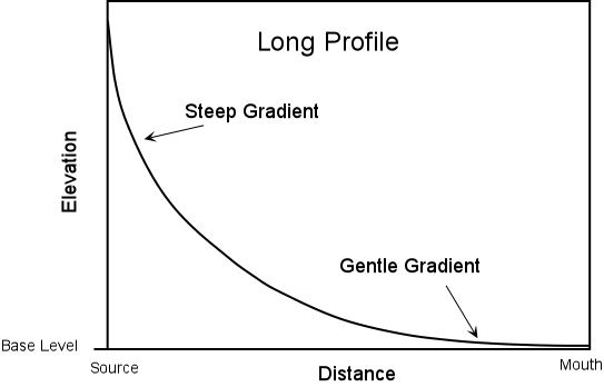
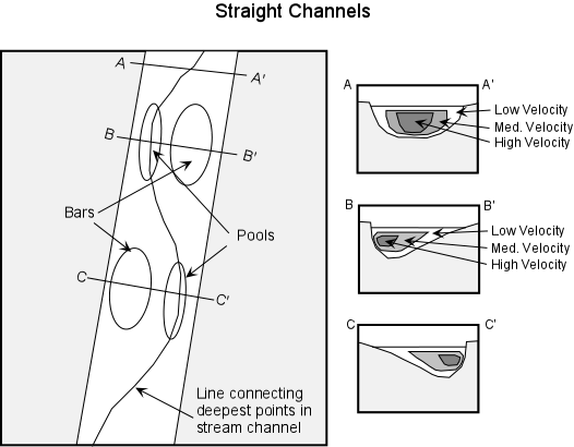
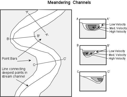
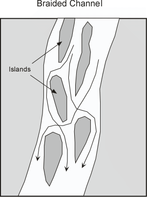
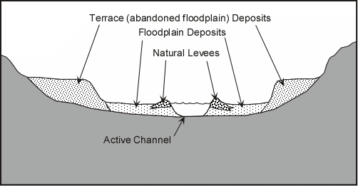

Stream Systems

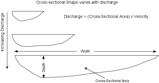
A stream is a body of water that carries rock particles and dissolved ions and flows down slope along a clearly defined path, called a channel. Thus streams may vary in width from a few centimeters to several kilometers. Streams are important for several reasons

  • Streams carry most of the water that goes from the land to the sea, and thus are an important part of the water cycle.

  • Streams carry billions of tons of sediment to lower elevations, and thus are one of the main transporting mediums in the production of sedimentary rocks.
  • Streams carry dissolved ions, the products of chemical weathering, into the oceans and thus make the sea salty.

  • Streams are a major part of the erosional process, working in conjunction with weathering and mass wasting. Much of the surface landscape is controlled by stream erosion, evident to anyone looking out of an airplane window.

  • Streams are a major source of water and transportation for the world's human population. Most population centers are located next to streams.
       
Geometry and Dynamics of Stream Channels

The stream channel is the conduit for water being carried by the stream. The stream can continually adjust its channel shape and path as the amount of water passing through the channel changes The volume of water passing any point on a stream is called the discharge. Discharge is measured in units of volume/time (m3/sec).


  • Cross Sectional Shape - varies with position in the stream and discharge. The deepest parts of a channel occur where the stream velocity is the highest. Both width and depth increase downstream because discharge increases downstream. As discharge increases the cross sectional shape will change, with the stream becoming deeper and wider.

XSectShp.GIF (11151 bytes)

  • Long Profile - a plot of elevation versus distance. Usually shows a steep gradient near the source of the stream and a gentle gradient as the stream approaches its mouth.

LongProf.GIF (10871 bytes)

  • Velocity - A stream's velocity depends on position in the stream channel, irregularities in the stream channel caused by resistant rock, and stream gradient.

    Friction slows water along channel edges. Friction is greater in wider, shallower streams and less in narrower, deeper streams. In straight channels, highest velocity is in the center.

    Deepest part of the channel is called the thalweg - meanders with curve the of the stream. 
    Flow follows a spiral path.

    In curved channels - maximum velocity traces the outside curve where the channel is preferentially scoured and deepened. On the inside of the curve were the velocity is lower, deposition of sediment occurs. 

    Stream flow can be either laminar, in which all water molecules travel along similar parallel paths, or turbulent, in which individual particles take irregular paths. Turbulent flow can keep sediment in suspension longer than laminar flow and aids in erosion of the stream bottom.


Stream flow is characteristically turbulent, with flow being chaotic and erratic, with abundant mixing, swirling eddies, and high velocity. The turbulence is caused by obstructions and shear in the water. Turbulent eddies scour the channel bed, and can keep sediment in suspension longer than laminar flow and thus aids in erosion of the stream bottom.

  • Discharge - The discharge of a stream is the amount of water passing any point in a given time.

    Q = A x V
 

Discharge (m3/sec) = Cross-sectional Area (width x average depth) (m2) x Average Velocity (m/sec)


    As the amount of water in a stream increases, the stream must adjust its velocity and cross sectional area in order to form a balance. Discharge increases as more water is added through rainfall, tributary streams, or from groundwater seeping into the stream. As discharge increases, generally width, depth, and velocity of the stream also increase. Increasing the depth and width of the stream may cause the stream to overflow is channel resulting in a flood.

  • Load - The rock particles and dissolved ions carried by the stream are the called the stream's load. Stream load is divided into three parts:
    • Suspended Load - particles that are carried along with the water in the main part of the stream. The size of these particles depends on their density and the velocity of the stream. Higher velocity currents in the stream can carry larger and denser particles.  The suspended load is what gives most streams their muddy looking appearance and brown or red color. When the velocity of the stream is decreased, that particles in the suspended load that can no longer be suspended are deposited.
       
    • Bed Load - coarser and denser particles that remain on the bed of the stream most of the time but move by a process of saltation (jumping) as a result of collisions between particles and turbulent eddies. Note that sediment can move between bed load and suspended load as the velocity of the stream changes.


Saltation.GIF (8164 bytes)


    • Dissolved Load - ions that have been introduced into the water by chemical weathering of rocks. This load is invisible because the ions are dissolved in the water.Dissolved load consists mostly of HCO-3 (bicarbonate ions), Ca+2, SO4-2, Cl-, Na+, Mg+2, and K+.  These ions are eventually carried to the oceans and give the oceans their salty character.  Streams that have a deep underground source generally have higher dissolved load than those whose source is on the Earth's surface.

The maximum size of particles that can be carried as suspended load by the stream is called stream competence. The maximum load carried by the stream is called stream capacity

Competence and capacity increase with increasing discharge. At high discharge boulder and cobble size material can move. At low discharge - larger fragments become stranded and only the smaller, sand, silt, and clay sized fragments move. 


  • Changes Downstream - As one moves along a stream in the downstream direction:

    • Discharge increases, as noted above, because water is added to the stream from tributary streams and groundwater.

    • As discharge increases, the width, depth, and average velocity of the stream increase.

    • The gradient of the stream, however, will decrease.

    • The size of particles that make up the bed load of the stream tends to decrease.

      Even though the velocity of the stream increases downstream, the bed load particle size decreases mainly because the larger particles are left in the bed load at higher elevations and abrasion of particles tends to reduce their size.


    It may seem to be counter to your observations that velocity increases in the downstream direction, since when one observes a mountain stream near the headwaters where the gradient is high, it appears to have a higher velocity than a stream flowing along a gentle gradient. But, the water in the mountain stream is likely flowing in a turbulent manner, due to the large boulders and cobbles which make up the streambed. If the flow is turbulent, then it takes longer for the water to travel the same linear distance, and thus the average velocity is lower.

Floods occur when the discharge of the stream becomes too high to be accommodated in the normal stream channel. When the discharge becomes too high, the stream widens its channel by overtopping its banks and flooding the low-lying areas surrounding the stream. The areas that become flooded are called floodplains.

Channel Patterns


  • Straight Channels - Straight stream channels are rare. Where they do occur, the channel is usually controlled by a linear zone of weakness in the underlying rock, like a fault or joint system. Even in straight channel segments water flows in a sinuous fashion, with the deepest part of the channel changing from near one bank to near the other. Velocity is highest in the zone overlying the deepest part of the stream. In these areas, sediment is transported readily resulting in pools. Where the velocity of the stream is low, sediment is deposited to form bars. The bank closest to the zone of highest velocity is usually eroded and results in a cutbank.

StraightCh.GIF (27053 bytes)


  • Meandering Channels - Because of the velocity structure of a stream, and especially in streams flowing over low gradients with easily eroded banks, straight channels will eventually erode into meandering channels. Erosion will take place on the outer parts of the meander bends where the velocity of the stream is highest. Sediment deposition will occur along the inner meander bends where the velocity is low. Such deposition of sediment results in exposed bars, called point bars. Because meandering streams are continually eroding on the outer meander bends and depositing sediment along the inner meander bends, meandering stream channels tend to migrate back and forth across their flood plain.

Meander.GIF (25898 bytes)

If erosion on the outside meander bends continues to take place, eventually a meander bend can become cut off from the rest of the stream. When this occurs, the cutoff meander bend, because it is still a depression, will collect water and form a type of lake called an oxbow lake.


  • Braided Channels - In streams having highly variable discharge and easily eroded banks, sediment gets deposited to form bars and islands that are exposed during periods of low discharge. In such a stream the water flows in a braided pattern around the islands and bars, dividing and reuniting as it flows downstream. Such a channel is termed a braided channel. During periods of high discharge, the entire stream channel may contain water with the islands covered to become submerged bars. During such high discharge, some of the islands could erode, but the sediment would be re-deposited as the discharge decreases, forming new islands or submerged bars. Islands may become resistant to erosion if they become inhabited by vegetation.
Braided.GIF (14966 bytes)
Erosion by Streams

Streams erode because they have the ability to pick up rock fragments and transport them to a new location. The size of the fragments that can be transported depends on the velocity of the stream and whether the flow is laminar or turbulent. Turbulent flow can keep fragments in suspension longer than laminar flow. Streams can also erode by undercutting their banks resulting in mass-moveement processes like slumps or landslides. When the undercut material falls into the stream, the fragments can be transported away by the stream. Streams can cut deeper into their channels if the region is uplifted.  As they cut deeper into their channels the stream removes the material that once made up the channel bottom and sides.

Although slow, as rocks move along the stream bottom and collide with one another, abrasion of the rocks occurs, making smaller fragments that can then be transported by the stream. Because some rocks and minerals are easily dissolved in water, dissolution also occurs, resulting in dissolved ions being transported by the stream. 

Stream Deposits

Sudden decreases in velocity can result in deposition by streams. Within a stream we have seen that the velocity varies with position, and, if sediment gets moved to the lower velocity part of the stream the sediment will come out of suspension and be deposited. Other sudden changes in velocity that affect the whole stream can also occur. For example if the discharge is suddenly increased, as it might be during a flood, the stream will overtop its banks and flow onto the floodplain where the velocity will then suddenly decrease. This results in deposition of such features as levees and floodplains. If the gradient of the stream suddenly changes by emptying into a flat-floored basin, an ocean basin, or a lake, the velocity of the stream will suddenly decrease resulting in deposition of sediment that can no longer be transported. This can result in deposition of such features as alluvial fans and deltas.

  • Floodplains and Levees - As a stream overtops its banks during a flood, the velocity of the flood will first be high, but will decrease as the water flows out over the gentle gradient of the floodplain. Because of the sudden decrease in velocity, the coarser grained suspended sediment is deposited along the riverbank, eventually building up a natural levee. Natural levees provide some protection from flooding because with each flood the levee is built higher and discharge must be higher for the next flood to occur. (Note that the levees we see along the Mississippi River in New Orleans are not natural levees, but human-made levees, built to protect the floodplain from floods).

FloodPlain.GIF (11892 bytes)


  • Terraces - Terraces are exposed former floodplain deposits that result when the stream begins down cutting into its flood plain (this is usually caused by regional uplift or by lowering the regional base level, such as a drop in sea level).

  • Alluvial Fans - When a steep mountain stream enters a flat valley, there is a sudden decrease in gradient and velocity. Sediment transported in the stream will suddenly become deposited along the valley walls in an alluvial fan. As the velocity of the mountain stream slows it becomes choked with sediment and breaks up into numerous distributary channels.


AllFan.GIF (14909 bytes)

  • Deltas - When a stream enters a standing body of water the sudden decrease in velocity causes deposition of sediment in a deposit called a delta. Deltas build outward from the coast, but only survive if the ocean currents are not strong enough to remove the sediment. As the velocity of a stream decreases on entering the delta, the stream becomes choked with sediment and conditions become favorable to those of a braided stream channel, but, instead of braiding, the stream breaks into many smaller streams called distributary streams.
Delta.GIF (16779 bytes)


Draina
ge Systems

Steamflow begins when water is added to the surface from rainfall, melting snow, and groundwater.

  • Drainage Basins and Divides - Drainage systems develop in such a way as to efficiently move water off the land. Streamflow begins as moving sheetwash.  Water moves down the steepest slope and starts to erode the surface by creating small rill channels.As the rills coalesce, deepen, and downcut into channels larger channels form.

    Rapid erosion lengthens the channel upslope in a process called headward erosion. Over time, nearby channels merge with smaller tributaries joining a larger trunk stream.The linked channels become a drainage network. With continued erosion of the channels, drainage networks change over time.
     
    Each stream in a drainage system drains a certain area, called a drainage basin. In a single drainage basin, all water falling in the basin drains into the same stream. Drainage basins can range in size from a few km 2, for small streams, to extremely large areas, such as the Mississippi River drainage basin which covers about 40% of the contiguous United States.  A divide separates each drainage basin from other drainage basins.


DrainageBasins.GIF (24623 bytes)

  • Drainage Patterns - Drainages tend to develop along zones where rock type and structure are most easily eroded. Thus various types of drainage patterns develop in a region and these drainage patterns reflect the structure of the rock.  

    Dendritic drainage patterns are most common.  They develop on a land surface where the underlying rock is of uniform resistance to erosion.  Radial drainage patterns develop surrounding areas of high topography where elevation drops from a central high area to surrounding low areas. 
DrainPat.GIF (16195 bytes)

Rectangular drainage patterns develop where linear zones of weakness, such as joints or faults cause the streams to cut down along the weak areas in the rock.

  • Permanent Streams - Streams that flow throughout most of the year are called permanent streams. Their surface is at or below the water table. They oOccur in humid or temperate climates where there is sufficient rainfall and low evaporation rates.  Water levels rise and fall with the seasons, depending on the discharge.
 
  • Ephemeral Streams - Streams that only occasionally have water flowing are called ephemeral streams or dry washes. They are above the water table and occur in dry climates with low amounts of rainfall and high evaporation rates.They flow mostly during rare flash floods and are dangerous because people forget that they are indeed stream channels when water is present.


Examples of questions on this material that could be asked on an exam

  1. What are the main causes of floods?

  2. Define the following: (a) stream long profile, (b) stream gradient, (c) stream discharge, (d) suspended load, (e) bed load, (f) stream competence, (g) stream capacity, (h) drainage basin, (i) drainage divide

  3. What happens to a stream's discharge as one moves down stream?  Explain why this occurs.

  4. List and give a brief description of the various types of stream deposits.

  5. What conditions are necessary for a stream to be meandering stream and a braided stream?

  6. How do streams erode?

  7. What is the difference between a permanent stream and an ephemeral stream?


References

Return to EENS 3050 Homepage