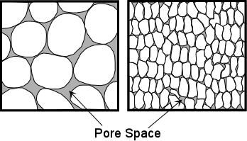
- Well-rounded coarse-grained sediments usually have higher porosity than fine-grained sediments, because the grains do not fit together well.
| EENS 1110 |
Physical Geology
|
| Tulane University |
Prof. Stephen A. Nelson
|
Groundwater |
|
|
|
Groundwater is water that exists in the pore spaces and fractures in rock and sediment beneath the Earth's surface. It originates as rainfall or snow, and then moves through the soil into the groundwater system, where it eventually makes its way back to surface streams, lakes, or oceans.
The Groundwater System Groundwater resides in the void spaces of rock, sediment, or soil, completely filling the voids. The total volume of open space in which the groundwater can reside is porosity. Porosity determines the amount of water that a rock or sediment can contain.
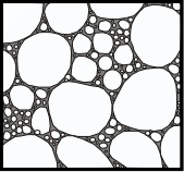
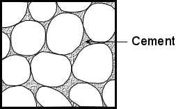
Porosity In sediments or sedimentary rocks the porosity depends on grain size, the shapes of the grains, and the degree of sorting, and the degree of cementation.
|
|
|
|
 |
|
 |
|
 |
Secondary porosity is porosity that developed after rock formation. Processes such as fracturing, faulting, and dissolution can create secondary porosity. |
Permeability is a measure of the degree to which the pore spaces are interconnected, and the size of the interconnections. Low porosity usually results in low permeability, but high porosity does not necessarily imply high permeability. It is possible to have a highly porous rock with little or no interconnections between pores. A good example of a rock with high porosity and low permeability is a vesicular volcanic rock, where the bubbles that once contained gas give the rock a high porosity, but since these holes are not connected to one another the rock has low permeability. |
| A thin layer of water will always be attracted to mineral grains due to the unsatisfied ionic charge on the surface. This is called the force of molecular attraction. If the size of interconnections is not as large as the zone of molecular attraction, the water can't move. | 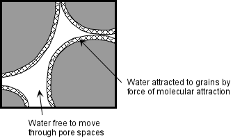 |
Thus, coarse-grained rocks are usually more permeable than fine-grained rocks, and sands are more permeable than clays. |
|
Aquifers An aquifer is a large body of permeable material where groundwater is present and fills all pore space. Good aquifers are those with high permeability such as poorly cemented sands, gravels, or highly fractured rock. An aquitard is a body of material with very low permeability. In general, tightly packed clays, well cemented sandstones, and igneous and metamorphic rocks lacking fractures are good aquitards. Large aquifers can be excellent sources of water for human usage such as the High Plains Aquifer (in sands and gravels) or the Floridian Aquifer (in porous limestones) as outlined in your text. Aquifers can be of two types:
|
| The Water Table | |
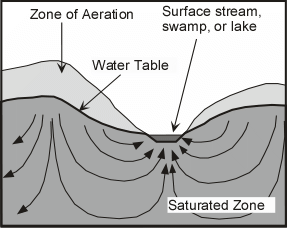
| Rain that falls on the surface seeps down through the soil and into a zone called the zone of aeration or unsaturated zone (also called the vadose zone), where most of the pore spaces are filled with air. As it penetrates deeper it eventually enters a zone where all pore spaces and fractures are filled with water. | 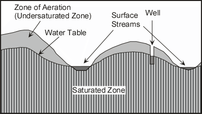 |
This zone is called the saturated zone or phreatic zone . The surface below which all openings in the rock are filled with water (the top of the saturated zone) is called the water table. The water table occurs everywhere beneath the Earth's surface. In desert regions it is always present, but rarely intersects the surface. |
|
| In more humid regions it reaches the surface at streams and lakes, and generally tends to follow surface topography. The depth to the water table may change, however, as the amount of water flowing into and out of the saturated zone changes. | 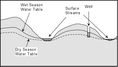 |
| During dry seasons, the depth to the water table increases. During wet seasons, the depth to the water table decreases. | |
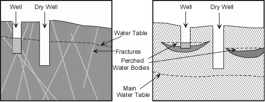
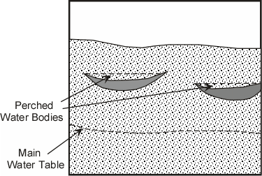
Discontinuous aquitards and aquifers may exist in the subsurface. These arrest downward infiltration to the water table and form what are called perched water tables. They overlie unsaturated material and may be confused with the main water table. Because they are smaller, they are more easily dewatered or contaminated. |
 |
|
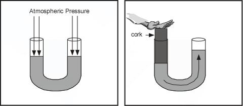
Movement of Groundwater Groundwater is in constant motion, although the rate at which it moves is generally slower than it would move in a stream because it must pass through the intricate passageways between free space in the rock. First the groundwater moves downward due to the pull of gravity. But it can also move upward because it will flow from higher pressure areas to lower pressure areas, as can be seen by a simple experiment illustrated below. Imagine that we have a "U"-shaped tube filled with water. If we put pressure on one side of the tube, the water level on the other side rises, thus the water moves from high pressure zones to low pressure zones. |
|
|
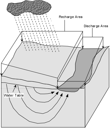
The same thing happens beneath the surface of the Earth, where pressure is higher beneath the hills and lower beneath the valleys |
 |
The Earth's surface can be divided into areas where some of the water falling on the surface seeps into the saturated zone and other areas where water flows out of the saturated zone onto the surface. Areas where water enters the saturated zone are called recharge areas, because the saturated zone is recharged with groundwater beneath these areas. Areas where groundwater reaches the surface (lakes, streams, swamps, & springs) are called discharge areas, because the water is discharged from the saturated zone. Generally, recharge areas are greater than discharge areas. |
 |
Groundwater movement is slow relative to that in surface streams. This is because it must percolate through pore openings and is further slowed by friction and electrostatic forces.
Ocean currents - 3 km /hour Groundwater flow occurs on a variety of scales. Local – Shallow flow occurs over short times and distances, whereas, deep long distance flow occurs over time scales of centuries. |
|
| The rate at which groundwater moves through the saturated
zone depends on the permeability of the rock and the hydraulic head. The
hydraulic head is defined as the difference in elevation between two points on the water table. |
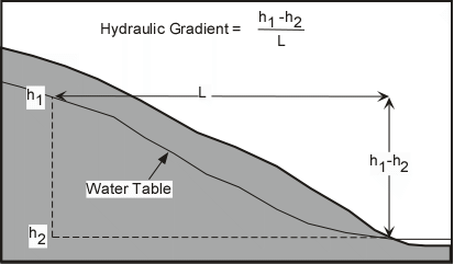 |
The hydraulic gradient is the hydraulic head divided by the distance between two points on the water table. |
|
The velocity, V, is of groundwater flow is given by: V = K(h2- h1)/L where K is the hydraulic conductivity, which is a measure of the permeability of the material through which the water is following. If we multiply this expression by the area, A, through which the water is moving, then we get the discharge, Q. Q = AK(h2 - h1)/L which is Darcy's Law. It simply states that discharge is proportional to the hydraulic gradient times the permeability. Discharge is higher if the hydraulic gradient is high and/or of the permeability is high. Note that like stream discharge, Q has units of volume per time (i.e. cubic meters per second). |
|
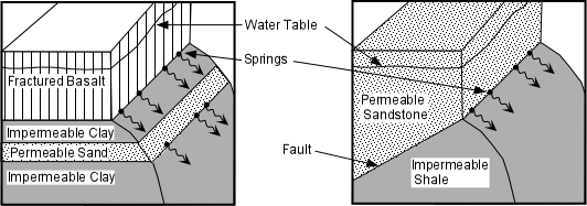
Springs A spring is an area on the surface of the Earth where the water table intersects the surface and water flows out of the ground. Some springs occur when an aquitard intersects an aquifer at the surface of the Earth . Such juxtaposition between permeable and impermeable rock can occur along geological contacts and fault zones (see figure 19.10 in your text for other examples), |
|
|
|
Hot Springs and Geysers Hot springs are groundwater discharges of water with temperatures that range from 30° to 104°C. The waters are usually rich in dissolved minerals that often precipitate around the springs. They develop in two settings: (1) where deep groundwater surfaces along faults or fractures, and (2) in geothermal regions where groundwater is heated by shallow magma or hot rock. Hot springs are distinctive geological features. If the surface through volcanic ash they become a viscous slurry called mudpots. If they precipitate dissolved minerals on cooling, they can form deposits like travertine made of calcite. Hot springs can also produce a wide range of colors due to thermal sensitive bacteria that metabolize sulfur minerals. Geysers form when hot water erupts to the surface. They are caused by boiling of the water at depth which causes vapor bubbles to rise and reduce the pressure. This results in rapid boiling which sends the water to the surface as a geyser. The cycle then repeats after the empty chamber is refilled with water and is heated to the boiling temperature. See http://mysite.du.edu/~jcalvert/geol/geyser.htm Hot springs and geysers are common in active volcanic regions, notably Yellowstone Park in Wyoming. Wells A well is human-made hole that is dug or drilled deep enough to intersect the water table. Wells are usually used as a source for groundwater. If the well is dug beneath the water table, water will fill the open space to the level of the water table, and can be drawn out by a bucket or by pumping. Fracture systems and perched water bodies can often make it difficult to locate the best site for a well. |
|
|
|
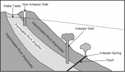
A special kind of confined aquifer is an artesian system, shown below. In an artesian system, the aquifer is confined between aquitards and is included so that the pressure inside the aquifer can push the water from a well or spring upward to nearly the same level as the top of the water table. Artesian systems are desirable because they result in free flowing artesian springs and artesian wells. |
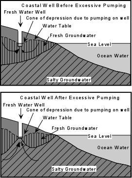
Changes in the Groundwater System When discharge of groundwater exceeds recharge of the system, several adverse effects can occur. Most common is lowering of the water table, resulting in springs drying up and wells having to be dug to deeper levels. If water is pumped out of an aquifer, pore pressure can be reduced in the aquifer that could result in compaction of the now dry aquifer and result in land subsidence. In some cases withdrawal of groundwater exceeds recharge by natural processes, and thus groundwater should be considered a non-renewable natural resource. |
|
Water Quality and Groundwater Contamination Water quality refers to such things as the temperature of the water, the amount of dissolved solids, and lack of toxic and biological pollutants. Water that contains a high amount of dissolved material through the action of chemical weathering can have a bitter taste, and is commonly referred to as hard water. Hot water can occur if water comes from a deep source or encounters a cooling magma body on its traverse through the groundwater system. Such hot water may desirable for bath houses or geothermal energy, but is not usually desirable for human consumption or agricultural purposes. Most pollution of groundwater is the result of biological activity, much of it human. Among the sources of contamination are:
|
|
Groundwater contamination can result from a point source where the contaminant plume emanates from 1 spot. Concentrations of the contaminant are highest near the source and decrease away from the source. Or, from a widespread source where the pollution is introduced over a wide area and diffused throughout the groundwater over a broad region. Nonpoint source contaminants are difficult to identify and address. Groundwater contaminant plumes change over time.
They grow in length with groundwater flow.
They grow in width by diffusion and dispersion. Remediation of Groundwater Contamination Problems In order to begin remediation , contaminant characterization is first done. Monitoring wells are installed to assess flow behavior. This allows for chemical testing to quantify the amount of and character of the contaminants. Strategies are then designed to reduce health risks. Remediation is usually quite expensive. Most strategies include removing the source of the contaminant, then pumping the groundwater out and treating it. Sometimes heat is pumped in to volatilize the groundwater or steam is pumped in to clean out the containments. Newly developed techniques uses bacteria to clean the groundwater in a process called bioremediation. Prevention of Groundwater Contamination Contamination is best prevented by managing land uses.
Landfills now require lining the bottom of the landfill with impermeable clay and plastic liners.
Underground storage tanks require double-lining to prevent leakage.
|
|
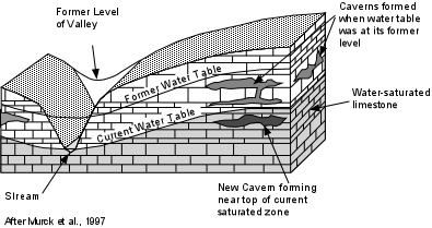
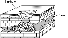
Geologic Activity of Groundwater
|
|
|
 |
|
|
|
Examples of questions on this material that could be asked on an exam.
|