EENS 3050 | Natural Disasters |
Tulane University | Prof. Stephen A. Nelson |
Earthquake Hazards and Risks |
|
Earthquake Risk
Examples:
|
Architecture and Building Codes While architecture and building codes can reduce risk, it should be noted that not all kinds of behavior can be predicted.
|
Hazards Associated with Earthquakes Possible hazards from earthquakes can be classified as follows: Ground Motion - Shaking of the ground caused by the passage of seismic waves, especially surface waves, near the epicenter of the earthquake are responsible for the most damage during an earthquake and is thus a primary effect of an earthquake. The intensity of ground shaking depends on:
Faulting and Ground Rupture - Ground rupture generally occurs
only along the
fault zone that moves during the earthquake, and are thus a primary effect. Thus structures that are built across fault
zones may collapse, whereas structures built adjacent to, but not crossing the fault may
survive. Aftershocks - These are smaller earthquakes that occur after a
main earthquake, and in most cases there are many of these (1260 were measured after the
1964 Alaskan Earthquake). Aftershocks occur because the main earthquake changes the stress
pattern in areas around the epicenter, and the crust must adjust to these changes.
Aftershocks are very dangerous because they cause further collapse of structures damaged
by the main shock. Aftershocks are a secondary effect of earthquakes Fire - Fire is a secondary effect of earthquakes. Because power lines
may be knocked down and because natural gas lines may rupture due to an earthquake, fires
are often started closely following an earthquake. The problem is compounded if water
lines are also broken during the earthquake since there will not be a supply of water to
extinguish the fires once they have started. In the 1906 earthquake in San Francisco more
than 90% of the damage to buildings was caused by fire. Landslides - In mountainous regions subjected to earthquakes ground shaking may trigger landslides, rock and debris falls, rock and debris slides, slumps, and debris avalanches. These are secondary effects.
|
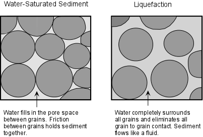
Liquefaction - Liquefaction is a processes that occurs in water-saturated unconsolidated sediment due to shaking. In areas underlain by such material, the ground shaking causes the grains to lose grain to grain contact, and thus the material tends to flow. |
|
Liquefaction, because it is a direct result of ground shaking, is a primary effect. You can demonstrate this process to yourself next time your go the beach.
Stand on the sand just after an incoming wave has passed. The sand will easily support
your weight and you will not sink very deeply into the sand if you stand still. But, if
you start to shake your body while standing on this wet sand, you will notice that the
sand begins to flow as a result of liquefaction, and your feet will sink deeper into the
sand. |
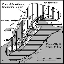
Changes in Ground Level - A secondary or tertiary effect that is caused by faulting. Earthquakes may cause both uplift and subsidence of the land surface. During the 1964 Alaskan Earthquake, some areas were uplifted up to 11.5 meters, while other areas subsided up to 2.3 meters.
Tsunami - Tsunami a secondary effect that are giant ocean waves that can rapidly travel across oceans, as will be discussed in more detail later. Earthquakes that occur beneath sea level and along coastal areas can generate tsunami, which can cause damage thousands of kilometers away on the other side of the ocean. |
Flooding - Flooding is a secondary effect that may occur due to rupture of human made dams and levees, due to tsunami, and as a result of ground subsidence after an earthquake. |
World Distribution of Earthquakes |
|
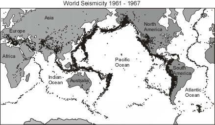
The distribution of earthquakes is called seismicity. Seismicity is highest along relatively narrow belts that coincide with plate boundaries. This makes sense, since plate boundaries are zones along which lithospheric plates move relative to one another. |
Earthquakes along these zones can be divided into shallow focus earthquakes that have focal depths less than about 100 km and deep focus earthquakes that have focal depths between 100 and 700 km. |
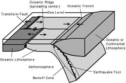
Earthquakes at Diverging Plate Boundaries. Diverging plate boundaries are zones where two plates move away from each other, such as at oceanic ridges. In such areas the lithosphere is in a state of tensional stress and thus normal faults and rift valleys occur. Earthquakes that occur along such boundaries show normal fault motion, have low Richter magnitudes, and tend to be shallow focus earthquakes with focal depths less than about 20 km. Such shallow focal depths indicate that the brittle lithosphere must be relatively thin along these diverging plate boundaries.
Earthquakes at Transform Fault Boundaries. Transform fault boundaries are plate boundaries where lithospheric plates slide past one another in a horizontal fashion. The San Andreas Fault of California is one of the longer transform fault boundaries known. Earthquakes along these boundaries show strike-slip motion on the faults and tend to be shallow focus earthquakes with depths usually less than about 100 km. Richter magnitudes can be large.
Earthquakes at Convergent Plate Boundaries. Convergent plate
boundaries are boundaries where two plates run into each other. Thus, they tend to be
zones where compressional stresses are active and thus reverse faults or thrust faults are
common. There are two types of converging plate boundaries. (1) subduction boundaries,
where oceanic lithosphere is pushed beneath either oceanic or continental lithosphere; and
(2) collision boundaries where two plates with continental lithosphere collide.
|
|
|
|
Collision boundaries - At collisional boundaries two plates of continental lithosphere collide resulting in fold-thrust mountain belts. Earthquakes occur due to the thrust faulting and range in depth from shallow to about 200 km.
Intraplate Earthquakes - These are earthquakes that occur in the stable portions of continents that are not near plate boundaries. Many of them occur as a result of re-activation of ancient faults, although the causes of some intraplate earthquakes are not well understood.
|
Seismic Hazard and Risk Mapping The risk that an earthquake will occur close to where you live depends on whether or not tectonic activity that causes deformation is occurring within the crust of that area.
Another way of looking a seismic risk that is more useful to construction designers and engineers, and therefore to the development of building codes, is based on expected horizontal ground acceleration. Acceleration is measured relative to the acceleration due to gravity (g = 980 cm/sec2). Ground accelerations of 0.1g are considered able to cause damage. An Earthquake hazard risk map is shown for the World, U.S. and Canada on page
79 of your text.
|
Examples of questions on this material that could be asked on an exam
|