TIDE-1220

New Orleans & Hurricanes

Tulane University

Prof. Stephen A. Nelson

Tropical Cyclones (Hurricanes)
Fall 2014


Before discussing the science of tropical cyclones (hurricanes as they are called when in the Atlantic or eastern Pacific oceans), we need to first understand something about atmospheric circulation in the lower part of the atmosphere (troposphere).

Atmospheric Circulation

The troposphere undergoes circulation because of convection.  Convection is a mode of heat transfer wherin the heat moves with the material.   Warm air, becuase it is less dense than cooler air, rises and cold air sinks back toward the surface.  Convection in the atmosphere is mainly the result of the fact that more of the Sun's heat energy is received by parts of the Earth near the Equator than at the poles.

Thus air at the equator is heated reducing its the density.  Lower density causes the air to rise.  At the top of the troposphere this air spreads toward the poles. 

WindsNoRotation.GIF (19488 bytes)
If the Earth were not rotating, this would result in a convection cell, with warm moist air rising at the equator, spreading toward the poles along the top of the troposphere, cooling as it moves poleward, then descending at the poles, as shown in the diagram above. Once back at the surface of the Earth, the dry cold air would circulate back toward the equator to become warmed once again.

Areas where warm air rises and cools are centers of low atmospheric pressure.  In areas where cold air descends back to the surface, pressure is higher and these are centers of high atmospheric pressure.


The Coriolis Effect - Again, the diagram above would only apply to a non-rotating Earth.  Since the Earth is in fact rotating, atmospheric circulation patterns are much more complex.  The reason for this is the Coriolis Effect.  The Coriolis Effect causes any body that moves on a rotating planet to turn to the right (clockwise) in the northern hemisphere and to the left (counterclockwise) in the southern hemisphere. The effect is negligible at the equator and increases both north and south toward the poles.  Coreolis.GIF (6265 bytes)

The Coriolis Effect occurs because the Earth rotates out from under all moving bodies like water, air, and even airplanes.  Note that the Coriolis effect depends on the initial direction of motion and not on the compass direction.  If you look along the initial direction of motion the mass will be deflected toward the right in the northern hemisphere and toward the left in the southern hemisphere. 


Wind Systems
  • Low Pressure Centers - In zones where air ascends, the air is less dense than its surroundings and this creates a center of low atmospheric pressure, or low pressure center. Winds blow from areas of high pressure to areas of low pressure, and so the surface winds would tend to blow toward a low pressure center.  But, because of the Coriolis Effect, these winds are deflected.  In the northern hemisphere they are deflected to toward the right, and fail to arrive at the low pressure center, but instead circulate around it in a counter clockwise fashion as shown here.  In the southern hemisphere the circulation around a low pressure center would be clockwise.  Such winds are called cyclonic winds.
            
LowPressure.GIF (3313 bytes)
  • High Pressure Centers - In zones where air descends back to the surface, the air is more dense than its surroundings and this creates a center of high atmospheric pressure. Since winds blow from areas of high pressure to areas of low pressure, winds spiral outward away from the high pressure.  But, because of the Coriolis Effect, such winds, again will be deflected toward the right in the northern hemisphere and create a general clockwise rotation around the high pressure center.  In the southern hemisphere the effect is just the opposite, and winds circulate in a counterclockwise rotation about the high pressure center. Such winds circulating around a high pressure center are called anticyclonic winds.

HighPress.GIF (4810 bytes)
Winds.GIF (40979 bytes)
  • Because of the Coriolis Effect, the pattern of atmospheric circulation is broken into belts as shown here. 


    • The rising moist air at the equator creates a series of low pressure zones along the equator.  Water vapor in the moist air rising at the equator condenses as it rises and cools causing clouds to form and rain to fall.  After this air has lost its moisture, it spreads to the north and south, continuing to cool, where it then descends at the mid-latitudes (about 30o North and South). 
    • Descending air creates zones of high pressure, known as subtropical high pressure areas.  Because of the rotating Earth, these descending zones of high pressure veer in a clockwise direction in the northern hemisphere, creating winds that circulate clockwise about the high pressure areas, and giving rise to winds, called the trade winds, that blow from the northeast back towards the equator.  In the southern hemisphere the air circulating around a high pressure center is veered toward the left, causing circulation in a counterclockwise direction, and giving rise to the southeast trade winds blowing toward the equator.
    • Near the equator, where the trade winds converge, is the Intertropical Convergence Zone (ITCZ)
    • Air circulating north and south of the subtropical high pressure zones generally blows in a westerly direction in both hemispheres, giving rise to the prevailing westerly winds.


      • These westerly moving air masses again become heated and start to rise creating belts of subpolar lows.  Meeting of the air mass circulating down from the poles and up from the subtropical highs creates a polar front which gives rise to storms where the two air masses meet.  In general, the surface along which a cold air mass meets a warm air mass is called a front.

      • The position of the polar fronts continually shifts slightly north and south, bringing different weather patterns across the land.  In the northern hemisphere, the polar fronts shift southward  to bring winter storms to much of the U.S.  In the summer months, the polar fronts shift northward, and warmer subtropical air circulates farther north.
    • The convection cells circulating upward from the equator and then back to surface at the mid-latitudes are called Hadley cells. Circulation upward at high latitudes with descending air at the poles are called Polar cells. In between are cells referred to as Ferrel cells.

    • At high altitudes in the atmosphere narrow bands of high velocity winds flowing from west to east are called the jet streams.  The polar jet occurs above the rising air between the Polar cells and the Ferrel cells.  The subtropical jet occurs above the descending air between the Ferrel cells and the Hadley cells. These jet streams meander above the earth's surface in narrow belts.  In the northern hemisphere, where the jet streams meanders to the south it brings low pressure centers (and associated storms) further to the south.  Where it meanders to the north, the high pressure centers move to the north.


Water and Heat

Water has one of the highest heat capacities of all known substances.  This means that it takes a lot of heat to raise the temperature of water by just one degree.  Water thus absorbs a tremendous amount of heat from solar radiation, and furthermore, because solar radiation can penetrate water easily, large amounts of solar energy are stored in the world's oceans. 


Further energy is absorbed by water vapor as the latent heat of vaporization, which is the heat required to evaporate water or change it from a liquid to a vapor.  This latent heat of vaporization is given up to the atmosphere when water condenses to form liquid water as rain.  If the rain changes to a solid in the form of snow or ice, it also releases a quantity of heat known as the latent heat of fusion. 

Thus, both liquid water and water vapor are important in absorbing heat from solar radiation and transporting and redistributing this heat around the planet.

LatentHeat.GIF (7555 bytes)

This heat provides the energy to drive the convection system in the atmosphere and thus drives the water cycle and is responsible for such hazards as floods, thunderstorms, tornadoes, and tropical cyclones.


Air Masses

Due to general atmospheric circulation patterns, air masses containing differing amounts of heat and moisture move into and across North America.  Polar air masses, containing little moisture and low temperatures move downward from the poles.  Air masses that form over water are generally moist, and those that form over the tropical oceans are both moist and warm. Because of the Coriolis effect due to the Earth's rotation, air masses generally move across North America from west to east.  But, because of the differences in moisture and heat, the collision of these air masses can cause instability in the atmosphere.
AirMasses.GIF (20063 bytes)


Fronts and Mid-latitude Cyclones
Different air masses with different temperatures and moisture content, in general, do not mix when they run into each other, but instead are separated from each other along boundaries called fronts.  When cold air moving down from the poles encounters warm moist air moving up from the Gulf of Mexico, Pacific Ocean, or Atlantic Ocean, a cold front develops and the warm moist air rises above the cold front.

This rising moist air cools as it rises causing the condensation of water vapor to form rain or snow.  Note that the cold air masses tend to circulate around a low pressure center in a counterclockwise fashion in the northern hemisphere.  Such circulation around a low pressure center is called a mid-latitude cyclone.  Frontmap.GIF (11095 bytes)
When warm air moving northward meets the cooler air to the north, a warm front forms.  As the warm air rises along a gently inclined warm front, clouds tend to form, and can also cause rain, but rain is less likely because the warm front is not as steep as a cold front.   If the rapidly moving cold front overtakes the warm front, an occluded front forms, trapping warm air above a layer of cold and cool air.  Mid-latitude cyclones and their associated fronts are responsible for such severe weather conditions as thunderstorms, snow storms and associated hail, lightening, and occasional tornadoes.
 

Hurricanes (Tropical Cyclones)

Tropical Cyclones  are massive tropical cyclonic storm systems with winds exceeding 119 km/hr (74 miles/hour).  The same phenomena is given different names in different parts of the world.  In the Atlantic Ocean and eastern Pacific ocean they are called hurricanes.  In the western Pacific they are called typhoons, and in the southern hemisphere they are called cyclones.  But, no matter where they occur they represent the same process.  Tropical cyclones are dangerous because of their high winds, the storm surge produced as they approach a coast, and the severe thunderstorms associated with them. Although death due to hurricanes has decreased in recent years due to better methods of forecasting and establishment of early warning systems, the economic damage from hurricanes has increased as more and more development takes place along coastlines.  It should be noted that coastal areas are not the only areas subject to hurricane damage.  Although hurricanes loose strength as they move over land, they still carry vast amounts of moisture onto the land causing thunderstorms with associated flash floods and mass-wasting hazards.

Origin of Hurricanes

  • When a cold air mass is located above an organized cluster of tropical thunderstorms, an unstable atmosphere results. (This is called a tropical wave). This instability increases the likelihood of convection, which leads to strong updrafts that lift the air and moisture upwards, creating an environment favorable for the development of high, towering clouds. A tropical disturbance is born when this moving mass of thunderstorms maintains its identity for a period of 24 hours or more.  This is  the first stage of a developing hurricane.
     

HurrDev1.GIF (18619 bytes)

  • Surface convergence (indicated by the small horizontal arrows in the diagram below) causes rising motion around a surface cyclone (labeled as "L"). The air cools as it rises (vertical arrows) and condensation occurs.  The condensation of water vapor to liquid water releases the latent heat of condensation into the atmosphere. This heating causes the air to expand, forcing the air to diverge at the upper levels (horizontal arrows at cloud tops).

HurDev2.GIF (34293 bytes)

  • Since pressure is a measure of the weight of the air above an area, removal of air at the upper levels subsequently reduces pressure at the surface. A further reduction in surface pressure leads to increasing convergence (due to an higher pressure gradient), which further intensifies the rising motion, latent heat release, and so on. As long as favorable conditions exist, this process continues to build upon itself.  When cyclonic circulation begins around the central low pressure area, and wind speeds reach 62 km/hr (39 mi/hr) the disturbance is considered a tropical storm and is given a name.  When wind speeds reach 119 km/hr (74 mi/hr) it becomes a hurricane.   Note that all tropical waves, disturbances, or storms do not necessarily develop into hurricanes.

To undergo these steps to form a hurricane, several environmental conditions must first be in place:

  1. Warm ocean waters (of at least 26.5°C [80°F]) throughout about the upper 50 m of the tropical ocean must be present.  The heat in these warm waters is necessary to fuel the tropical cyclone.
  2. The atmosphere must cool fast enough with height, such that it is potentially unstable to moist convection. It is the thunderstorm activity which allows the heat stored in the ocean waters to be liberated and used for tropical cyclone development.
  3. The mid-troposphere (5 km [3 mi] altitude), must contain enough moisture to sustain the thunderstorms. Dry mid levels are not conducive to the continuing development of widespread thunderstorm activity.
  4. The disturbance must occur at a minimum distance of at least 500 km [300 mi] from the equator. For tropical cyclonic storms to occur, there is a requirement that the Coriolis force must be present.  Remember that the Coriolis effect is zero near the equator and increases to the north and south of the equator.  Without the Coriolis force, the low pressure of the disturbance cannot be maintained.
  1. There must be a pre-existing near-surface disturbance that shows convergence of moist air and is beginning to rotate. Tropical cyclones cannot be generated spontaneously. They require a weakly organized system that begins to spin and has low level inflow of moist air.
  2. There must be low values (less than about 10 m/s [20 mph]) of vertical wind shear between the surface and the upper troposphere. Vertical wind shear is the rate of change of wind velocity with altitude.  Large values of vertical wind shear disrupt the incipient tropical cyclone by removing the rising moist air too quickly, preventing the development of the tropical cyclone. Or, if a tropical cyclone has already formed, large vertical shear can weaken or destroy it by interfering with the organization around the cyclone center.
Hurricanes thus commonly develop in areas near, but not at the equator, as shown in the diagram below.  As they move across the oceans their paths are steered by the presence of existing low and high pressure systems, as well as the Coriolis force. The latter force causes the storms to eventually start turning to the right in the northern hemisphere and to the left in the southern hemisphere. 

Note that about 12% of all tropical cyclones develop in the Atlantic Ocean. Those that begin to form near the coast of Africa are often referred to as "Cape Verde" hurricanes, because the area in which they develop is near the Cape Verde Islands.  15% of all tropical cyclones develop in the eastern Pacific Ocean, 30% develop in the western Pacific Ocean, 24% in the Indian Ocean both north and south of the equator, and 12% develop in the southern Pacific Ocean.  It is notable that essentially no tropical cyclones develop south of the Equator in the Atlantic Ocean, although one occurred off the coast of Brazil in March of 2004..


HurrDev.GIF (24530 bytes)

After Abbott (1996)


Tropical Cyclone Structure
Because the converging winds spiral inward toward the central low pressure area, the winds rotate in a counterclockwise direction around the central low in the northern hemisphere (clockwise in the southern hemisphere).  As these winds spiral inward they draw in the thunderclouds around the storm, creating the spiral rain bands that are clearly visible on satellite images of the storm (recall satellite images of hurricanes that are seen frequently on TV during hurricane season).  HurricaneStruct.GIF (28728 bytes)
As the winds converge toward the central core, they spiral upwards, sending warm moist air upwards. As this air rises, it cools and releases its latent heat into the atmosphere to add further energy to the storm. The winds spiraling around this central core create the eye of the tropical cyclone and eventually spread out at high altitudes.  Eventually, cool air above the eye begins to sink into the central core. This dry descending air within the eye gives the core a clear, cloud free sky, with little to no wind. 

Since the main source of energy for the storm is the heat contained in the warm tropical and subtropical oceans, if the storm moves over the land, it is cut off from its source of heat and will rapidly dissipate.

HurVel.GIF (12110 bytes) 

Winds spiraling counterclockwise (in the northern hemisphere) into the eye of the hurricane achieve high velocities as they approach the low pressure of the eye.  The velocity of these winds is called the hurricane-wind velocity.  The central low pressure center of the eye also moves across the surface of the Earth as it is pushed by regional winds.  The velocity at which the eye moves across the surface is called the storm center velocity.  Thus, when we consider the velocity of winds around the hurricane we must take into account both the wind velocity and the storm center velocity. Depending on the side of the hurricane, these velocities can either add or subtract.  In the example at the left, the hurricane is traveling north with a storm center velocity of 30 km/hr, and a hurricane-wind velocity of 150 km/hr. On the right hand side of the storm both velocities are to the north so the total wind velocity is 180 km/hr (30 + 150). On the left hand side of the storm, however, the wind is blowing to the south.
Thus, since the storm is moving in the opposite direction to the winds, the velocities subtract and the total wind velocity is 120 km/hr (150 - 30).  This is an important point.  Winds are always stronger on the right side of a moving hurricane in the northern hemisphere.  (The opposite is true in the southern hemisphere, since winds circulate in a clockwise direction, the winds are stronger on the left-hand side of the storm in the southern hemisphere).

Tropical Cyclone Size

Since winds spiral inward toward the central low pressure area in the eye of a hurricane, hurricane-wind velocity increases toward the eye.  The distance outward from the eye to which hurricane strength winds occur determines the size of the hurricane.  Winds in the eye wall itself have the highest velocity and this zone can extend outward from the center to distances of 16 to 40 km.   Hurricane force winds (winds with velocities greater than 119 km/hr) can extend out to 120 km from the center of the storm.  The largest tropical cyclone recorded, Typhoon Tip,  had gale force winds (54 km/hr) which extended out for 1100 km in radius in the Northwest Pacific in 1979. Hurricane Katrina, in 2005, was a large hurricane with tropical storm force winds extending outward from the eye about 320 km. 

The smallest, Cyclone Tracy,  had gale force winds that only extended 50 km in radius when it struck Darwin, Australia, in 1974.  There is very little association between hurricane  intensity (either measured by maximum sustained winds or by central pressure) and size.  Hurricane Andrew is a good example of a very intense tropical cyclone of small size.  It had 922 mb central pressure and 230 km/hr sustained winds at landfall in Florida, but had gale force winds extending out to only about 150 km from the center.

Hurricane Intensity and Frequency
Once a hurricane develops, the Saffir-Simpson Scale is used to classify a hurricane's intensity and damage potential. There are five possible categories. Category 1 storms are more common than category 5 storms.  In a typical year, there may be many category 1 storms, but category 5 storms occur very infrequently.

Saffir-Simpson Hurricane Damage-Potential Scale

Scale Number
Category

Central Pressure
mb
(inches of mercury)

Wind Speeds
mi/hr
(km/hr)

Storm Surge*
feet
(meters)

Observed
Damage

1 >980
(>28.94)
74-95
(119-153)
4-5
(1.2-1.5)
some damage to trees, shrubbery, and unanchored mobile homes
2 965-979
(28.50-28.91)
96-110
(154-177)
6-8
(1.8-2.4)
major damage to mobile homes; damage buildings' roofs, and blow trees down
3 945-964
(27.91-28.47)
111-130
(178-209)
9-12
(2.5-3.6)
destroy mobile homes; blow down large trees; damage small buildings
4 920-944
(27.17-27.88)
131-155
(210-249)
13-18
(3.9-5.5)
completely destroy mobile homes; lower floors of structures near shore are susceptible to flooding
5 <920
(<27.17)
>155
(>250)
>18
(>5.5)
extensive damage to homes and industrial buildings; blow away small buildings; lower floors of structures within 500 meters of shore and less than 4.5 m (15 ft) above sea level are damaged
*Note that surge level is highly dependent on such factors as the recent history of the storm, the shape of the coastline, and the bathymetry of the sea floor along the coast.  The numbers in this column should be used with caution in predicting storm surge levels.Note that beginning in 2010, the National Hurricane Center no longer assoicates the storm category based on wind speed with the height of the storm surge because the relationship is not well established.


Again, because a hurricane derives its energy from the warm ocean waters in the topics and subtropics, hurricanes are more frequent in the late summer months.  Thus, as seen in the graph, hurricanes in the Atlantic ocean are more frequent in the months of August, September and October. The peak occurs on September 10. Very few have been recorded in January through April.


Monitoring and Tracking Hurricanes

In the United States, hurricanes and developing tropical disturbances are monitored very closely.  Such monitoring has drastically reduced the number of deaths from hurricanes in the last 50 years.  Monitoring is conducted using several methods:

MonthlyHurr.GIF (8610 bytes)
  • Ships at sea transmit weather reports that help meteorologists locate centers of low pressure that may develop into tropical disturbances. 

  • Images from weather satellites, which are collected every 30 minutes, are then scanned to look for any development or growth of the disturbance.  In particular, the images are examined to detect any rotational development of the storm, an indication that it may be approaching tropical storm strength.

  • If a tropical storm or hurricane is detected and appears to pose a threat to land areas, observation airplanes are sent to examine the storm.  Such planes fly into the storm at an altitude of about 3,000 meters or lower. The plane collects data on wind speed,  air pressure, and moisture content by dropping devices called dropsondes into the storm.  These dropsondes transmit the meteorological data continuously has they fall to the ocean surface, and thus provide information on the vertical structure of the storm.  In addition, radar devices carried on the plane collect data about the intensity of the rainfall and wind velocities.  The planes fly completely through the storm, passing though the eye, sometimes making several passes.  The data collected give meteorologists a 3 dimensional picture of the structure of the storm.

  • Satellite images and radar from land based stations allow scientists to track the position of the storm and report it to all agencies that may be affected if the storm makes landfall.

Changes in Hurricane Tracks and Intensities
Because hurricanes are influenced by large-scale air masses, they sometimes move along rather erratic paths.  Hurricanes are especially influenced by the strength and direction of upper level winds.  As noted above, strong upper level winds create a vertical wind shear that cause the top of the hurricane to be sheared off and result in the loss of strength of the storm.  The erratic nature of a hurricane's path often makes it difficult to predict where and when it will make landfall prior to several hours before it actually does make landfall.  In the lower latitudes, near the equator, hurricanes generally are pushed by the easterly trade winds and have storm center velocities that are relatively low (8 to 32 km/hr).  As they move northward, storm center velocities generally increase to greater than 50 km/hr. 

This increase in storm center velocity usually results from the interaction of the storm with other air masses.  Off the eastern coast of the United States there is an area of semi-permanent high pressure, known as the Bermuda High. Other high pressure centers are continually moving eastward off of North America.  If the hurricane encounters a low pressure trough between two high pressure centers, it is steered into the trough and follows it along a northeastward trend, increasing its velocity as it does so.

Interaction with the land and other air masses are most responsible for changes in hurricane tracks and intensities.  Some examples are shown on the map below. Two of the most erratic hurricane paths recorded are shown by Hurricane Betsy, in 1965 and Hurricane Elena in 1985. 
 
  • Hurricane Betsy, a category 3 storm, took a northwestward track from the Caribbean Islands, but then turned abruptly west as it passed north of Puerto Rico.  It then took a  northwest track again, looking like it would hit  along the coast of Georgia or South Carolina. 
HurTrack.GIF (21244 bytes)


    Suddenly, however, it looped back to the south, passed over the southern tip of Florida, crossed the Gulf of Mexico and hit just east of New Orleans.

    In Florida and Louisiana it caused about $10.8 billion (2004 dollars) in damage and killed 76 people along its track.

  • Hurricane Elena became a hurricane over the southeastern tip of Cuba in 1985.  It took a northwestward track looking like it would head to New Orleans, but on entering the northern Gulf of Mexico, it turned abruptly toward the east, taking aim on the west coast of Florida. It stalled for about 2 days just south of Pensacola, Florida, then abruptly turned toward the northwest, eventually hitting the coast as a category 3 storm at Biloxi, Mississippi, where it caused $2.6 billion  (2004 dollars) in damages.
  • Hurricane Donna in 1960 shows the effects of  the land decreasing the intensity of a hurricane.  Donna hit the southern tip of Florida as a category 4 hurricane. It then took a northeastward track across Florida, loosing strength as it crossed the land.  On re-entering the Atlantic Ocean it again increased in intensity due to the warm ocean waters, took a track along the east coast and eventually hit Long Island, New York. This storm caused about $3 billion (2004 dollars) in damages and killed over 364 people along its track.

  • In 1992 Hurricane Andrew moved west across southern Florida causing about $30 billion in damages.  It weakened somewhat as it crossed Florida, but on entering the Gulf of Mexico it strengthened, crossed the Gulf and plowed into southwestern Louisiana causing an additional $16 billion in damages, but killed only 26 people along its track.

Angle of Hurricane Approach to Coast
The amount of damage that occurs when a hurricane approaches a coast depends on the angle of approach.   Two extreme examples illustrate this point. 
CoastHurr.GIF (12905 bytes)
  • A hurricane that moves along the coast has a coast-parallel hurricane track. From such a track extensive damage would occur along the coastline closest to the storm, with bands of lesser damage extending inland.  Since this track (upper diagram) has the most intense winds offshore (on the right side of the hurricane), the coast would not feel the highest wind velocities.  Thunderstorm activity associated with this track would be most severe on the northern side of the storm, since the spiral rain bands would be feeding off the moist air above the ocean.
  • A hurricane that approaches the perpendicular to the coast  has a coast-normal track.  Such a storm would produce extreme damage all along the right-hand side of its track, with bands of decreasing damage occurring both to the left and right of the track. Furthermore, as the storm approached the coast areas to right hand side of the storm would receive the heaviest thunderstorm activity, since the rain bands would be feeding off the moist oceanic air.
Hurricanes with a coast-parallel track  have the additional danger that small shifts in course make landfall forecasts difficult.

 
Storm Surge
Heavy winds produced by hurricanes push the ocean in front of them. As this water gets pushed into the shallow zones along the coastline sea level rises.  Since the storm surge is driven by the winds, the height of the rise in sea level is related to the velocity of the wind.  For a moving storm the greater winds occur on the right side of the storm (in the northern hemisphere).  Sea level also rises beneath the eye of the storm due to the low pressure in the eye.  But, the surge generated by this low pressure is usually much less than the wind-driven surge.  The height of the storm surge depends on wind speed, the shape of the coastline, and variations in the water depth along the coast line. 
 
Height also depends on tidal cycles.  If a storm approaches the coast during high tide, the storm surge will be higher than if it approaches during low tide. 
StSurge.GIF (14544 bytes)
Category 5 tropical cyclones can produce storm surges in excess of  6m (20 feet).  The highest storm surge measured, 12.8 m (42 feet) occurred in 1899 in Australia.

Hurricane Katrina, in 2005, produced a 8.5 m (28 ft) storm surge along the Mississippi Gulf coast even though it was a category 3 hurricane when it made landfall.  This high storm surge was due to the fact that only 24 hours before landfall it had been a category 5 hurricane and the water pushed in front of it was trapped along the Louisiana coast to the west where it could not escape.

Because the storm surge occurs ahead of the eye of the storm, the surge will reach coastal areas long before the hurricane makes landfall.  This is an important point to remember because flooding caused by the surge can destroy roads and bridges making evacuation before the storm impossible.
 

Since thunderstorms accompany hurricanes, and these storms can strike inland areas long before the hurricane arrives, water draining from the land in streams and estuaries may be impeded by the storm surge that has pushed water up the streams and estuaries. 

It is also important to remember that water that is pushed onto the land by the approaching storm (the flood surge) will have to drain off after the storm has passed.   Furthermore after passage of the storm the winds typically change direction and push the water in the opposite direction.  Damage can also be caused by the retreating surge, called the ebb surge.

Along coastal areas with barrier islands offshore, the surge may first destroy any bridges leading to the islands, and then cause water to overflow the islands.  Barrier islands are not very safe places to be during an approaching hurricane!
Hurricane Damage
Hurricanes cause damage as a result of the high winds, the storm surge, heavy rain, and tornadoes that are often generated from the thunderstorms as they cross land areas.  Strong winds can cause damage to structures, vegetation, and crops, as described in the Saffir-Simpson scale discussed previously.  The collapse of structures can cause death. The storm surge and associated flooding, however, is what is most responsible for casualties. Extreme cases of storm surge casualties have occurred as recently as 1970 and 1990 in Bangladesh and 2008 in Myanmar..  Bangladesh is an area with high population density and with over 30% of the land surface less than 6 m above sea level.  In 1970 a cyclone struck Bangladesh during the highest high tides (full moon).  The storm surge was 7 m (23 ft.) high and resulted in about 400,000 deaths.  Another cyclone in 1990 created a storm surge 6 m high and resulted in 148,000 deaths. The May 2008 cyclone in Myanmar is estimated to have killed 138,000.

The amount of damage caused by a tropical cyclone is directly related to the intensity of the storm, the duration of the storm (related to its storm-center velocity, as discussed above), the angle at which it approaches the land, and the population density along the coastline. The table below shows how damages are expected to increase with increasing tropical storm category.  Like the Richter scale for earthquakes, damage does not increase linearly with increasing hurricane category.


Category

Relative Damage

Median Damage (1995 Dollars)

1 1 $33 million
2 10 $336 million
3 50 $1.4 billion
4 250 $8.2 billion
5 500 $5.9 billion


Source: National Hurricane Center - http://www.aoml.noaa.gov/hrd/tcfaq/D5.html


Predicting Hurricane Frequency and Intensity
As discussed above, modern methods of weather forecasting involving satellites, radar, etc. allow accurate tracking of the development and paths of hurricanes.  In addition, computer models have been developed by the National Weather Service that enable the prediction of storm surge levels along the U.S. coast, given data on wind velocity, wind distribution, and storm center velocity. These models were accurate to within about 1 foot for the levels of the storm surge that accompanied Hurricane Hugo along the South Carolina coast in 1989 and Hurricane Katrina in 2005. Computer models have also been developed to predict the paths the storms will take and have met with moderate success. Accurate forecasting of storm tracks is more problematical because of the numerous variables involved and the erratic paths hurricanes sometimes take.  Still the National Hurricane Center's accuracy of hurricane tracks has improved steadily over the last 25 years.  As of 2002, the average error on a 24 hour forecast is - 80 mi., on the 48 hour forecast  - 110 mi., and on the 72 hour forecast - 230 mi.

Prediction of hurricane intensity (wind speed) is more problematic as too many factors are involved.  Hurricanes are continually changing their intensity as they evolve and move into different environments. Without the ability to know which environmental factors are going to change, it is very difficult to expect improvement on intensity forecasting.

Hurricane Katrina was expected to loose intensity as moved out of the warmer waters of the Gulf of Mexico. But, it showed a more rapid drop in intensity just before landfall because a mass of cooler dry air was pulled in from the northwest.

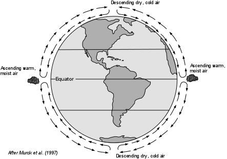
Some progress has been made in predicting the number and intensity of storms for the Atlantic Ocean  by Dr. William Gray of Colorado State University. He has shown that there is a correlation between the frequency of intense Atlantic hurricanes with the amount of rainfall in western Africa in the preceding year. This correlation has allowed fairly accurate forecasts of the number of storms of a given intensity that will form each year. The 1997 predictions, however, did not take into account the effects of El Niņo, which reduces the number of hurricanes. Nevertheless, Dr. Gray's predictions are closely watched, and have been otherwise fairly accurate.

Reducing Hurricane Damage
There is plenty of historical data on hurricane damage in the United States so that it is not difficult to see ways that damage from hurricanes can be reduced.  In terms of protection of human life, the best possible solution is to evacuate areas before a hurricane and its associated storm surge reaches coastal areas. Other measures can be undertaken to reduce hurricane damage as well.


  • Warning and Evacuation - With modern techniques of forecasting and tracking hurricane paths, it is always possible to issue warnings about the probable locations that will be affected by any given hurricane. The National Hurricane Center defines hurricane watches and warnings as follows:
    • Hurricane Watch: An announcement of specific coastal areas that a hurricane or an incipient hurricane condition poses a possible threat, generally within 36 hours.

    • Hurricane Warning: A warning that sustained winds  of 74 mph (119 km/hr) or higher associated with a hurricane are expected in a specified coastal area in 24 hours or less. A hurricane warning can remain in effect when dangerously high water or a combination of dangerously high water and exceptionally high waves continue, even though winds may be less than hurricane force.

    The problem, however, is that it may not always be possible to issue such a warning in time for adequate evacuation of these areas.  Because the storm surge and even gale force winds can reach an area many hours before the center of the storm, warnings must be issued long enough before the storm strikes that the surge and winds do not hinder the evacuation process.  The effectiveness of the warning systems also depends on the populace to heed the warning and evacuate the area rather than ride out the storm, and the state of preparedness of local government agencies in terms of evacuation and disaster planning.  New Orleans is a particularly notable example.  Since most of the city is at or below sea level, a storm surge of 6 meters (20 feet) from a category 4 or 5 hurricane would most certainly flood the city and choke all evacuation routes.  Even with 24 hours notice of the approaching surge (which would mean as soon as the storm entered the Gulf of Mexico) it would be difficult to evacuate or convince people to evacuate within that 24 hour period.   A hurricane approaching New Orleans was a disaster waiting to happen as we can all testify.

  • Maintaining Beach Width and Dune Height - Wide beaches, high dunes, and barrier islands offer natural protection from storm surges.  If beach width and dune height can be maintained or increased by  artificial processes, this could prevent some damage to structures lying inland from the beaches and dunes.
     
  • In Louisiana, restoring coastal marshes and land lost to recent erosion could reduce the storm surge that reaches populated parts of the region (like New Orleans).

  • Engineering Solutions - In 1900 the city of Galveston Texas was completely covered by the storm surge of an approaching hurricane.  Between 6,000 and 8,000 lives were lost.  Because of this devastation the entire city was elevated by 11 feet and a floodwall 16 feet above low tide was constructed all along the coast.  These engineering steps protected Galveston until 2008 and probably reduced damage due to Hurricane Ike in 2008. Still, Galveston was not spared by Ike.   Another approach, for cities on bays and estuaries is to build a moveable series of walls or gates across the mouth of the bay or estuary to prevent the storm surge from entering.  Such a structure was built across the mouth of Narragansett Bay, Rhode Island to protect the city of Providence after a 1938 hurricane.  Again the structure has proven effective.

  • Construction Codes - Rigorous enforcement of building codes can effectively reduce damage to structures.  In areas where high storm surges might be expected, codes could require construction that is built high enough to not flood and sturdy enough not to be knocked down by the surge or the winds that accompany a hurricane.  Damage to homes can be reduced by requiring aerodynamic architecture, such as rounded rather than angular shapes.  Wood frame home construction should require that each component of a house - foundation, floors, walls, and roof  - be anchored to the others with metal strips (hurricane clips) rather than just nailed together.

  • Zoning/Land Use Practices - As with other natural hazards like flooding, landslides, and coastal erosion, an alternative, although controversial practice of limiting coastal areas to recreational purposes could always reduce the vulnerability of such areas to damage from natural processes, including hurricanes.

References

Return to TIDE 1220 Homepage