EENS 1110

Physical Geology

Tulane University
Prof. Stephen A. Nelson

Deserts


Deserts

Deserts are areas where rainfall is less than 250 mm (10 in.)/year, or where evaporation exceeds precipitation. Thus, deserts are areas that we think of as arid.  They may be hot or cold.  They are characterized by specialized ecosystems and low human populations.  Because of their dryness, unique geologic processes operate in deserts.

Origin of Deserts

Deserts originate by several different mechanisms that result in five types of deserts.

  1. Subtropical deserts
  2. Rain shadow deserts
  3. Coastal deserts
  4. Continental interior deserts
  5. Polar deserts.

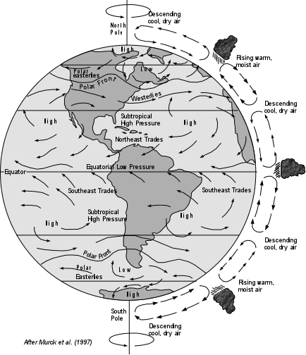
Subtropical Deserts - the general atmospheric circulation brings dry, subtropical air into mid-latitudes. Examples: Sahara of Northern Africa, Kalahari of Southern Africa, and the Great Australian Desert.

Winds.GIF (41711 bytes)

Rainshadow Deserts - Areas where mountainous regions cause air to rise and condense, dropping its moisture as it passes over the mountains. Examples: Deserts east of the Sierra Nevada Mountains, California & Nevada, East of the Cascades of Oregon and Washington, and East of the Andes Mountains in South America.

Coastal Deserts - Areas where cold upwelling seawater cools the air and decreases its ability to hold moisture. Examples : Atacama Desert of coastal Peru, Namib Desert of coastal South Africa. 

Continental Interior Deserts - Areas in the continental interiors, far from source of moisture where hot summers and cold winters prevail. Example: Gobi, Mongolia  


Polar Deserts - Cold polar regions where cold dry air prevails and moisture available remains frozen throughout the entire year. Examples: Northern Greenland, and ice-free areas of Antarctica.

We will concentrate on the first four types of deserts, the one's which occur in hot arid climates.

Surface Processes in Deserts

The same geologic processes operate in deserts as in other more humid climates. The difference is the intensity to which the processes act.

Weathering and Mass Movements

  • Deserts have little soil because moisture is so low and the rate of chemical weathering is slow.  Recall that chemical weathering is responsible for the formation of soils  Bedrock commonly occurs at the surface.  Exposed rock surfaces develop desert varnish a dark reddish brown surface coating of of iron and manganese oxides.  This forms very slowly by bacterial activity, dust, and water.

  • Little plant life develops because of lack of soils and water. Plants tend to hold soil and fine-grained rock fragments in place so without plants, erosional processes can remove the thin desert soils. 

  • Desert soils are usually colored like the bedrock nearby.  Trace elements in the soils bring out wide color variations.
  • The desert surface is dominated by mechanical weathering processes. Rock fragments tend to be angular, rather than rounded.

    If we compare the surface features of deserts with those in humid regions, we find that:

    • deserts are dominated by rock falls, rock slides, and the accumulation of coarse grained material, and generally have steeper slopes.

    • humid regions have soil and fine-grained regolith covering slopes, with creep being the dominant mass movement process, resulting in curved gentle slopes.

  • Cliffs of solid rock are common in desert regions. If the rock making up the cliff has numerous vertical joints and they are underlain by more easily eroded rocks like shales, erosion and mechanical weathering will eventually cause rock falls.  This results in cliff retreat. 

    If the cliff forming rocks have horizontal bedding planes, continued cliff retreat and stream erosion eventually form flat-tipped hills called mesas (mesa is Spanish for table) with areas of several square kilometers.  Small flat topped hills that become isolated from the mesas are called buttes, like are seen in Monument Valley, Arizona.  Smaller examples, where the height of the feature exceeds their top surface are called chimneys, like are seen in Bryce Canyon, Utah.

    If the cliff forming rocks have bedding planes that dip, then an asymmetrical ridge, called a cuesta will form.   The steep cliff forms on one side and a gentle slope parallel to the bedding planes forms on the other side.  This gentle slope is referred to as dip slope, because it is has the same angle as the dip of the bedding planes. (See figure 21.19a in your text).

Streams and Fluvial Landforms

Surface waters are rare in deserts. Streams that do flow usually originate at higher elevations and supply enough water for the stream to pass through the desert region without evaporating. Streams in deserts tend to be ephemeral, that is they flow only during rains. For this reason, flash floods and braided stream channels are common.  Because flash floods can have considerable discharge, rapid erosion can occur during these rare events. (Note that excellent photos of these features can be found in your textbook and will be shown in lecture).

  • Alluvial Fans and Bajadas - An alluvial fan forms where a mountain stream enters a broad flat valley and deposits sediment as its velocity decreases on entering the flatter valley. When a linear mountain range has several closely spaced valleys, the alluvial fans may coalesce to form a gentle undulated slope on the sides of the bounding lowlands. Such coalesced alluvial fans are known as Bajadas.
  • Pediments - A pediment is broad bedrock surface with a gentle slope away from highlands. With distance away from the highlands the pediment passes beneath a thin cover of alluvial sediment derived from erosion of the pediment. The highlands remain as residual hills as the pediment matures.
  • Playa Lakes - Standing bodies of water like lakes are rare in desert regions because rainfall and input from streams occurs only intermittently. Lakes that do form during the rare periods of rainfall, quickly evaporate, leaving a dry lake bed behind. Playa Lakes (also called dry lakes) are formed in basins of internal drainage. The lake beds often consist of salts (evaporites) that were carried in by streams and precipitated during evaporation. These precipitated salts give the dry lake bed a white color resembling a beach (playa means beach in Spanish).


Wind Erosion and Deposition

Wind is common in arid desert regions because:


  1. Air near the surface is heated and rises, cooler air comes in to replace hot rising air and this movement of air results in winds.

  2. Arid regions have little or no soil moisture to hold rock and mineral fragments.

Wind has the ability to transport, erode, and deposit sediment.

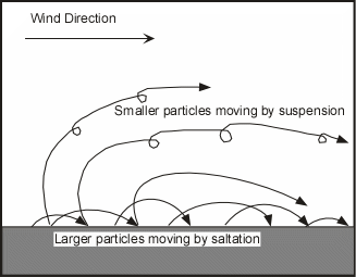
Sediment Transportation by Wind - Wind transports sediment near the surface by saltation. Just as in the bed load of streams, saltation refers to short jumps of grains dislodged from the surface and jumping a short distance. As the grains fall back to the surface they may dislodge other grains that then get carried by wind until they collide with ground to dislodge other particles. Smaller particles can become suspended in the wind and may travel for longer distances.


Sand Ripples - Occur as a result of larger grains accumulating as smaller grains are transported away. Ripples form in lines perpendicular to wind direction. These are similar to, but much smaller than dunes.

Wind blown dust - Sand sized particles generally do not travel very far in the wind, but smaller sized fragments can be suspended in the wind for much larger distances.


Wind Erosion - Wind can be effective agent of erosion anywhere that it is strong enough to act. Wind can erode by deflation and abrasion.

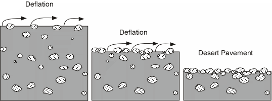
  • Deflation is the lowering of the land surface due to removal of fine-grained particles by the wind. Deflation concentrates the coarser grained particles at the surface, eventually resulting in a surface composed only of the coarser grained fragments that cannot be transported by the wind. Such a surface is called desert pavement.        


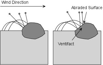
  • Ventifacts are any bedrock surface or stone that has been abraded or shaped by wind-blown sediment in a process similar to sand blasting.

  • Yardangs are streamlined wind-eroded ridges commonly found in deserts.


Wind Deposits

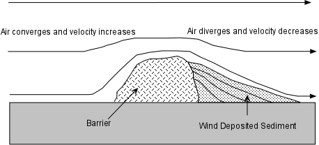
Wind can deposit sediment when its velocity decreases to the point where the particles can no longer be transported. This can happen when topographic barriers slow the wind velocity on both the upwind and downwind side of the barrier. As the air moves over the top of the barrier, streamlines converge and the velocity increases.

After passing over the barrier, the streamlines diverge and the velocity decreases. As the velocity decreases, some of the sediment in suspension can no longer be held in suspension, and thus drops out to form a deposit. 
Topographic barriers can be such things as rocks, vegetation, and human made structures that protrude above the land surface.
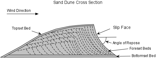
Sand Dunes - Sand dunes form when there is (1) a ready supply of sand, (2) a steady wind, and (3) some kind of obstacle such as vegetation, rocks, or fences, to trap some of the sand. Sand dunes form when moving air slows down on the downwind side of an obstacle. The sand grains drop out and form a mound that becomes a dune.  
  • Sand dunes are asymmetrical mounds with a gentle slope in the upwind direction and steep slope called a slip face on the downwind side. Dunes migrate by erosion of sand by wind (saltation) on the gentle upwind slope, and deposition and sliding on the slip face, and thus are cross-bedded deposits.

    Such cross-bedded deposits are often preserved in sandstones, such as the Navajo Sandstone in Zion National Park, Utah (see figure 21.22d in your text).
  • Dunes may cover large areas and reach heights up to 500m.
  • Types of sand dunes

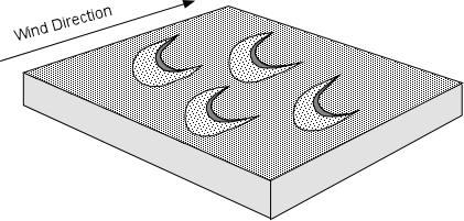
    Barchan Dunes - are crescent-shaped dunes with the points of the crescents pointing in the downwind direction, and a curved slip face on the downwind side of the dune. They form in areas where there is a hard ground surface, a moderate supply of sand, and a constant wind direction.

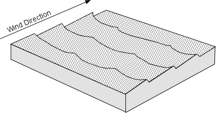
Transverse Dunes - are large fields of dunes that resemble sand ripples on a large scale. They consist of ridges of sand with a steep face in the downwind side, and form in areas where there is abundant supply of sand and a constant wind direction. Barchan dunes merge into transverse dunes if the supply of sand increases.


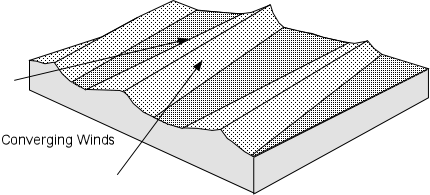
Longitudinal Dunes (also called Sief Dunes) - are long straight dunes that form in areas with a limited sand supply and converging wind directions.


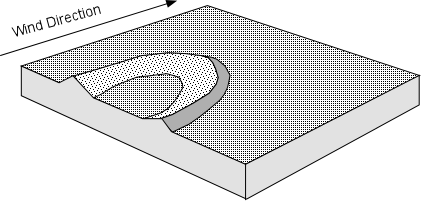
Parabolic (also called blowout) Dunes - are "U" shaped dunes with an open end facing upwind. They are usually stabilized by vegetation, and occur where there is abundant vegetation, a constant wind direction, and an abundant sand supply. They are common in coastal areas.


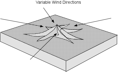
Star Dunes - are dunes with several arms and variable slip face directions that form in areas where there is abundant sand and variable wind directions.


  • Wind Blown Dust - Dust consists of silt and clay sized particles that are often packed together with smooth surface. Such packed dust is difficult to remove by wind erosion alone, unless the surface is very dry or is disturbed. When dust it is disturbed, dust storms may develop, and dust may be transported by the wind over large distances. Most soil contains some silt and clay particles deposited by the wind.

    A large deposits of wind deposited dust is called loess. Much loess was derived from debris left by glacial erosion and winds blowing across desert region s..

  • Dust in Ocean Sediments. -  Dust can be transported by the wind and by onto the surface of the oceans. Much of this wind blown dust originates in deserts.  As a result, much of the fine grained continent-derived sediment that reaches the abyssal plains of the oceans was originally transported by winds.

Desertification

Desertification occurs as a result of climatic changes, such as changing positions of the continents, changes in ocean and air circulation patterns.  The latter can be driven by changes in global temperature that occur naturally or as the result of human activities.   Human impacts, such as overgrazing, overpopulation, draining of land, and lowering of the groundwater table, can also contribute to desertification. As vegetation dies out, the soil is more easily eroded and may be lost so that other vegetation becomes destabilized. Since soil can hold moisture, if the soil erodes, the area may become arid, and the desert expands. 

Short term desertification took place on the great plains of the U.S. beginning in 1933 and lasting for several years.  It was initiated by drought conditions that resulted from unusual weather patterns, but was exacerbated by overpopulation and plowing of the soil which removed grasses that would normally hold the soil in place.  When the soil dried out, winds whipping across the area generated giant dust storms form which the period got its name - the Great Dust Bowl.  It resulted in famine and economic hardship for residents of the area, most of whom migrated out of the area.  Although the area has recovered, this episode of history shows how even short term changes in weather patterns and human interference with the land can lead to drastic consequences.

Long term desertification is also taking place in other parts of the world.  In particular, south of the Sahara desert in Africa, the Sahel, is a semi-arid grass land that has been subject to overpopulation, overuse of water resources, extensive agriculture, and overgrazing during the past 60 years.  The result has been desertification and resulting mass starvation of the human occupants of the land.


Examples of questions on this material that could be asked on an exam.

  1. What is a desert and what are the 5 types of deserts that occur on Earth?

  2. What are the following desert landforms (a) mesa, (b) butte, (c) chimney, (d) cuesta, (e) alluvial fans, (f) bajadas, (g) inselbergs.

  3. Define the following (a) desert varnish, (b) deflation (c) desert pavement, (d) playa lake, (e) ventifact, (f) yardang, (g) loess

  4. How do mass movement processes differ in deserts and more humid areas and what result do these differences have on the landscape of the areas?

  5. What the 5 types of sand dunes and what are the conditions necessary to form each?

  6. Explain how sand dunes can migrate across the surface.

  7. What natural and anthropogenic (human induced) factors can result in desertification.

Return to EENS 1110 Page