EENS 1110
Physical Geology
Tulane University

Prof. Stephen A. Nelson

Earthquakes and the Earth's Interior


Earthquakes

Earthquakes occur when energy stored in elastically strained rocks is suddenly released. This release of energy causes intense ground shaking in the area near the source of the earthquake and sends waves of elastic energy, called seismic waves, throughout the Earth. Earthquakes can be generated by bomb blasts, volcanic eruptions, sudden volume changes in minerals, and sudden slippage along faults. Earthquakes are definitely a geologic hazard for those living in earthquake prone areas, but the seismic waves generated by earthquakes are invaluable for studying the interior of the Earth.


In or discussion of earthquake we want to answer the following questions:

  1. What causes earthquakes?
  2. How are earthquakes studied?
  3. What happens during an earthquake?
  4. Where do earthquakes occur?
  5. Can earthquakes be predicted?
  6. Can humans be protected from earthquakes?
  7. What can earthquakes tell us about the interior of the earth?


Causes of Earthquakes

Within the Earth rocks are constantly subjected to forces that tend to bend, twist, or fracture them. When rocks bend, twist or fracture they are said to deform.  Strain is a change in shape, size, or volume. The forces that cause deformation are referred to as stresses.  To understand the causes of earthquakes we must first explore stress and strain.


Stress and Strain

Recall that stress is a force applied over an area. A uniform stress is where the forces act equally from all directions. Pressure is a uniform stress and is referred and is also called confining stress or hydrostatic stress. If stress is not equal from all directions then the stress is a differential stress.


Three kinds of differential stress occur.

  1. Tensional stress (or extensional stress), which stretches rock;

  2. Compressional stress, which squeezes rock; and


  3. Shear stress, which result in slippage and translation.
When a rock is subjected to increasing stress it changes its shape, size or volume. Such a change in shape, size or volume is referred to as strain.  When stress is applied to rock, the rock passes through 3 successive stages of deformation.
  • Elastic Deformation -- wherein the strain is reversible.
  • Ductile Deformation -- wherein the strain is irreversible.
  • Fracture -- irreversible strain wherein the material breaks.
stressstrain.gif (6755 bytes)
We can divide materials into two classes that depend on their relative behavior under stress.
  • Brittle materials have a small to large region of elastic behavior, but only a small region of ductile behavior before they fracture.
  • Ductile materials have a small region of elastic behavior and a large region of ductile behavior before they fracture.

How a material behaves will depend on several factors. Among them are:


  • Temperature - At high temperature molecules and their bonds can stretch and move, thus materials will behave in more ductile manner. At low Temperature, materials are brittle.

  • Confining Pressure - At high confining pressure materials are less likely to fracture because the pressure of the surroundings tends to hinder the formation of fractures. At low confining stress, material will be brittle and tend to fracture sooner.

  • Strain rate -- Strain rate refers to the rate at which the deformation occurs (strain divided by time). At high strain rates material tends to fracture. At low strain rates more time is available for individual atoms to move and therefore ductile behavior is favored.

  • Composition -- Some minerals, like quartz, olivine, and feldspars are very brittle. Others, like clay minerals, micas, and calcite are more ductile This is due to the chemical bond types that hold them together. Thus, the mineralogical composition of the rock will be a factor in determining the deformational behavior of the rock. Another aspect is presence or absence of water.

In general, rocks near the surface of the earth behave in a brittle fashion, unless they are deformed slowly.   Thus, when they are acted upon by differential stress, they tend to fracture. 

Faults

Most natural earthquakes are caused by sudden slippage along a fault.  Faults occur when brittle rocks fracture and there is displacement of one side of the fracture relative to the other side.  The amount of displacement in a single slippage event is rarely more that 10 to 20 m for large earthquakes, but after many events the displacement could be several hundred kilometers. 

Types of Faults

Faults can be divided into several different types depending on the direction of relative displacement or slip on the fault. Most faults make an angle with the ground surface, and this angle is called the dip angle.  If the dip angle is 90o the fault plane is vertical.  Faults can be divided into two major classes.  

Dip Slip Faults - Dip slip faults are faults that have an inclined fault plane and along which the relative displacement or offset has occurred along the dip direction. Note that in looking at the displacement on any fault we don't know which side actually moved or if both sides moved, all we can determine is the relative sense of motion.

    For any inclined fault plane we define the block above the fault as the hanging wall block and the block below the fault as the footwall block

  •  Normal Faults - are faults that result from horizontal extensional stresses in brittle rocks and where the hanging-wall block has moved down relative to the footwall block.


  • Reverse Faults - are faults that result from horizontal compressional stresses in brittle rocks, where the hanging-wall block has moved up relative the footwall block.
  • A Thrust Fault is a special case of a reverse fault where the dip of the fault is less than 45o. Thrust faults can have considerable displacement, measuring hundreds of kilometers, and can result in older strata overlying younger strata.

Strike Slip Faults - are faults where the displacement on the fault has taken place along a horizontal direction. Such faults result from shear stresses acting in the crust. Strike slip faults can be of two varieties, depending on the sense of displacement. To an observer standing on one side of the fault and looking across the fault, if the block on the other side has moved to the left, we say that the fault is a left-lateral strike-slip fault. If the block on the other side has moved to the right, we say that the fault is a right-lateral strike-slip fault. The famous San Andreas Fault in California is an example of a right-lateral strike-slip fault. Displacements on the San Andreas fault are estimated at over 600 km.

Oblique Slip Faults - If the displacement has both a vertical component and a horizontal component (i.e. a combination of dip slip and strike slip) it is called an oblique slip fault.

Blind Faults

A blind fault is one that does not break the surface of the earth.  Instead, rocks above the fault have behaved in ductile fashion and folded over the tip of the fault.

BlindThrust.GIF (11765 bytes)

Active Faults

An active fault is one that has shown recent displacement and likely has the potential to produce earthquakes.   Since faulting is part of the deformation process, ancient faults can be found anywhere that deformation has taken place in the past.  Thus, not every fault one sees is necessarily an active fault.  

Surface Expression of Faults

Where faults have broken the surface of the earth they can be delineated on maps and are called fault lines or fault zones.   Recent ruptures of dip slip faults at the surface show a cliff that is called a fault scarp.  Strike slip faults result in features like linear valleys, offset surface features (roads, stream channels, fences, etc.) or elongated ridges.(see figure 10.5 and10.37 in your textbook).


How Faults Develop
The elastic rebound theory suggests that if slippage along a fault is hindered such that elastic strain energy builds up in the deforming rocks on either side of the fault, when the slippage does occur, the energy released causes an earthquake.

This theory was discovered by making measurements at a number of points across a fault. Prior to an earthquake it was noted that the rocks adjacent to the fault were bending. These bends disappeared after an earthquake suggesting that the energy stored in bending the rocks was suddenly released during the earthquake.

Friction between the blocks then keeps the fault from moving again until enough strain has accumulated along the fault zone to overcome the friction and generate another earthquake.  Once a fault forms, it becomes a zone of weakness in the crust, and so long as the tectonic stresses continue to be present more earthquakes are likely to occur on the fault. Thus faults move in spurts and this behavior is referred to as Stick Slip.  If the displacement during an earthquake is large, a large earthquake will be generated.  Smaller displacements generate smaller earthquakes.  Note that even for small displacements of only a millimeter per year, after 1 million years, the fault will accumulate 1 km of displacement. 

Fault Creep - Some faults or parts of faults move continuously without generating earthquakes.  This could occur if there is little friction on the fault and tectonic stresses are large enough to move the blocks in opposite directions.  This is called fault creep.  Note that if creep is occurring on one part of a fault, it is likely causing strain to build on other parts of the fault. 

How Earthquakes Are Measured

When an earthquake occurs, the elastic energy is released and sends out vibrations that travel in all directions throughout the Earth. These vibrations are called seismic waves.

The point within the earth where the fault rupture starts is called the focus or hypocenter. 

This is the exact location within the earth were seismic waves are generated by sudden release of stored elastic energy.

The epicenter is the point on the surface of the earth directly above the focus. Sometimes the media get these two terms confused.

eqfocus.gif (8009 bytes)

Seismic Waves

Seismic waves emanating from the focus can travel in several ways, and thus there are several different kinds of seismic waves.

Body Waves - emanate from the focus and travel in all directions through the body of the Earth. There are two types of body waves: P-waves and S waves. seismicwaves.gif (6046 bytes)
  • P - waves - are Primary waves. They travel with a velocity that depends on the elastic properties of the rock through which they travel.


    Where, Vp is the velocity of the P-wave, K is the incompressibility of the material, μ is the rigidity of the material, and ρ is the density of the material.

    P-waves are the same thing as sound waves. They move through the material by compressing it, but after it has been compressed it expands, so that the wave moves by compressing and expanding the material as it travels. Thus the velocity of the P-wave depends on how easily the material can be compressed (the incompressibility), how rigid the material is (the rigidity), and the density of the material. P-waves have the highest velocity of all seismic waves and thus will reach all seismographs first.


  • S-Waves - Secondary waves, also called shear waves. They travel with a velocity that depends only on the rigidity and density of the material through which they travel:


    S-waves travel through material by shearing it or changing its shape in the direction perpendicular to the direction of travel. The resistance to shearing of a material is the property called the rigidity. It is notable that liquids have no rigidity, so that the velocity of an S-wave is zero in a liquid. (This point will become important later). Note that S-waves travel slower than P-waves, so they will reach a seismograph after the P-wave.

Surface Waves - Surface waves differ from body waves in that they do not travel through the earth, but instead travel along paths nearly parallel to the surface of the earth. Surface waves behave like S-waves in that they cause up and down and side to side movement as they pass, but they travel slower than S-waves and do not travel through the body of the Earth.  Love waves result in side to side motion and Rayleigh waves result in an up and down rolling motion.  (see figure 10.10 in your text).  Surface waves are responsible for much of the shaking that occurs during an earthquake.

The study of how seismic waves behave in the Earth is called seismology. Seismic waves are measured and recorded on instruments called seismometers.


Seismometers  
Seismic waves travel through the earth as elastic vibrations. A seismometer is an instrument used to record these vibrations and the resulting graph that shows the vibrations is called a seismogram.


The seismometer must be able to move with the vibrations, yet part of it must remain nearly stationary. This is accomplished by isolating the recording device (like a pen) from the rest of the Earth using the principal of inertia. For example, if the pen is attached to a large mass suspended by a spring, the spring and the large mass move less than the paper which is attached to the Earth, and on which the record of the vibrations is made.

The record of an earthquake, a seismogram, as recorded by a seismometer, will be a plot of vibrations versus time. On the seismogram time is marked at regular intervals, so that we can determine the time of arrival of the first P-wave and the time of arrival of the first S-wave.


(Note again, that because P-waves have a higher velocity than S-waves, the P-waves arrive at the seismographic station before the S-waves).


Locating the Epicenter of an Earthquake

In order to determine the location of an earthquake, we need to have recorded a seismogram of the earthquake from at least three seismographic stations at different distances from the epicenter. In addition, we need one further piece of information - that is the time it takes for P-waves and S-waves to travel through the earth and arrive at a seismographic station. Such information has been collected over the last 100 or so years, and is available as travel time curves.

From the seismographs at each station one determines the S-P interval (the difference in the time of arrival of the first S-wave and the time of arrival of the first P-wave. Note that on the travel time curves, the S-P interval increases with increasing distance from the epicenter. Thus the S-P interval tells us the distance to the epicenter from the seismographic station where the earthquake was recorded.

Thus, at each station we can draw a circle on a map that has a radius equal to the distance from the epicenter. Three such circles will intersect in a point that locates the epicenter of the earthquake.

Earthquake Size  

Whenever a large destructive earthquake occurs in the world the press immediately wants to know where the earthquake occurred and how big the earthquake was (in California the question is usually - Was this the Big One?). The size of an earthquake is usually given in terms of a scale called the Richter Magnitude. Richter Magnitude is a scale of earthquake size developed by a seismologist named Charles F. Richter. The Richter Magnitude involves measuring the amplitude (height) of the largest recorded wave at a specific distance from the earthquake. While it is correct to say that for each increase in 1 in the Richter Magnitude, there is a tenfold increase in amplitude of the wave, it is incorrect to say that each increase of 1 in Richter Magnitude represents a tenfold increase in the size of the Earthquake (as is commonly incorrectly stated by the Press).

A better measure of the size of an earthquake is the amount of energy released by the earthquake. The amount of energy released is related to the Magnitude Scale by the following equation:

Log E = 11.8 + 1.5 M

Where Log refers to the logarithm to the base 10, E is the energy released in ergs, and M is the Magnitude.

Anyone with a hand calculator can solve this equation by plugging in various values of M and solving for E, the energy released. I've done the calculation for you in the following table:

Magnitude

Energy (ergs)

Factor

1

2.0 x 10¹³

31 x

2

6.3 x 10¹⁴

3

2.0 x 10¹⁶

31 x

4

6.3 x 10¹⁷

5

2.0 x 10¹⁹

31 x

6

6.3 x 10²⁰

7

2.0 x 10²²

31 x

8

6.3 x 10²³

From these calculations you can see that each increase in 1 in Magnitude represents a 31 fold increase in the amount of energy released. Thus, a magnitude 7 earthquake releases 31 times more energy than a magnitude 6 earthquake. A magnitude 8 earthquake releases 31 x 31 or 961 times more energy than a magnitude 6 earthquake.

Although the Richter Magnitude is the scale most commonly reported when referring to the size of an earthquake, it has been found that for larger earthquakes a more accurate measurement of size is the moment magnitude, MwThe moment magnitude is a measure of the amount of strain energy released by the earthquake as determined by measurements of the shear strength of the rock and the area of the rupture surface that slipped during the earthquake.

  • Note that it usually takes more than one seismographic station to calculate the magnitude of an earthquake. Thus you will hear initial estimates of earthquake magnitude immediately after an earthquake and a final assigned magnitude for the same earthquake that may differ from initial estimates, but is assigned after seismologists have had time to evaluate the data from numerous seismographic stations.

  • The moment magnitude for large earthquakes is usually greater than the Richter magnitude for the same earthquake.  For example the Richter magnitude for the 1964 Alaska earthquake is usually reported as 8.6, whereas the moment magnitude for this earthquake is calculated at 9.2.  The largest earthquake ever recorded was in Chile in 1960 with a moment magnitude of 9.5, The Summatra earthquake of 2004 had a moment magnitude of 9.0.  Sometimes a magnitude is reported for an earthquake and no specification is given as to which magnitude (Richter or moment) is reported.  This obviously can cause confusion. But, within the last few years, the tendency has been to report the moment magnitude rather than the Richter magnitude. 

  • The Hiroshima atomic bomb released an amount of energy equivalent to a moment magnitude 6 earthquake.
  • Note that magnitude scales are open ended with no maximum or minimum. The largest earthquakes are probably limited by rock strength. Meteorite impacts could cause larger earthquakes than have ever been observed.


Frequency of Earthquakes of Different Magnitude Worldwide

Magnitude

Number of Earthquakes per Year

Description

> 8.5 0.3

Great

8.0 - 8.4 1
7.5 - 7.9 3

Major

7.0 - 7.4 15
6.6 - 6.9 56
6.0 - 6.5 210 Destructive
5.0 - 5.9 800 Damaging
4.0 - 4.9 6,200

Minor

3.0 - 3.9 49,000
2.0 - 2.9 300,000
  0 - 1.9 700,000


Modified Mercalli Intensity Scale

Note that the Richter magnitude scale results in one number for the size of the earthquake. Maximum ground shaking will occur only in the area of the epicenter of the earthquake, but the earthquake may be felt over a much larger area. The Modified Mercalli Scale was developed in the late 1800s  to assess the intensity of ground shaking and building damage over large areas.
  • The scale is applied after the earthquake by conducting surveys of people's response to the intensity of ground shaking and destruction.

Intensity

Characteristic Effects

Richter Scale Equivalent

I People do not feel any Earth movement <3.4
II A few people notice movement if at rest and/or on upper floors of tall buildings  
III People indoors feel movement. Hanging objects swing back and forth. People outdoors might not realize that an earthquake is occurring 4.2
IV People indoors feel movement. Hanging objects swing. Dishes, windows, and doors rattle. Feels like a heavy truck hitting  walls. Some people outdoors may feel movement. Parked cars rock. 4.3 - 4.8
V Almost everyone feels movement. Sleeping people are awakened. Doors swing open/close. Dishes break.  Small objects move or are turned over. Trees shake. Liquids spill from open containers 4.9-5.4
VI Everyone feels movement. People have trouble walking. Objects fall from shelves. Pictures fall off walls. Furniture moves. Plaster in walls may crack. Trees and bushes shake. Damage slight in poorly built buildings. 5.5 - 6.1
VII People have difficulty standing. Drivers feel cars shaking. Furniture breaks. Loose bricks fall from buildings. Damage slight to moderate in well-built buildings; considerable in poorly built buildings. 5.5 - 6.1
VIII Drivers have trouble steering. Houses not bolted down shift on foundations. Towers & chimneys twist and fall. Well-built buildings suffer slight damage. Poorly built structures severely damaged. Tree branches break. Hillsides crack if ground is wet. Water levels in wells change. 6.2 - 6.9
IX Well-built buildings suffer considerable damage. Houses not bolted down move off foundations. Some underground pipes broken. Ground cracks.   Serious damage to Reservoirs. 6.2 - 6.9
X Most buildings & their foundations destroyed. Some bridges destroyed. Dams damaged. Large landslides occur. Water thrown on the banks of canals, rivers, lakes. Ground cracks in large areas. Railroad tracks bent slightly. 7.0 - 7.3
XI Most buildings collapse. Some bridges destroyed. Large cracks appear in the ground. Underground pipelines destroyed. Railroad tracks badly bent. 7.4 - 7.9
XII Almost everything is destroyed. Objects  thrown into the air. Ground moves in waves or ripples. Large amounts of rock may move. >8.0
  • The Modified Mercalli Scale is shown in the table above. Note that correspondence between maximum intensity and Richter Scale magnitude only applies in the area around the epicenter.

  • A given earthquake will have zones of different intensity all surrounding a zone of maximum intensity.

  • The Mercalli Scale is very useful in examining the effects of an earthquake over a large area, because it will is responsive not only to the size of the earthquake as measured by the Richter scale for areas near the epicenter, but will also show the effects of the efficiency that seismic waves are transmitted through different types of material near the Earth's surface.

  • The Mercalli Scale is also useful for determining the size of earthquakes that occurred before the modern seismographic network was available (before there were seismographic stations, it was not possible to assign a Magnitude).

What Happens During an Earthquake?


Earthquakes produce several effects that cause damage and destruction. Some of these effects are the direct result of the ground shaking produced by the arrival of seismic waves and others are secondary effects.  Among these effects are the following:

Ground Shaking - Shaking of the ground caused by the passage of seismic waves near the epicenter of the earthquake is responsible for the collapse of most structures. The intensity of ground shaking depends on distance from the epicenter and on the type of bedrock underlying the area.  
  • In general, loose unconsolidated sediment is subject to more intense shaking than solid bedrock.

  • Damage to structures from shaking depends on the type of construction. Concrete and masonry structures, because they are brittle are more susceptible to damage than wood and steel structures, which are more flexible.

Different kinds of shaking occur due to passage of different kinds of waves. As the P-waves arrive the ground will move up and down.  The S-waves produce waves that both move the ground up and down and back and forth in the direction of wave motion.  The Love waves shake the ground from side to side, and the Rayleigh waves create a rolling up and down motion (see figure 10.26 in your text).

Ground Rupture - Ground rupture only occurs along the fault zone that moves during the earthquake. Thus, structures that are built across fault zones may collapse, whereas structures built adjacent to, but not crossing the fault may survive. 

Fire - Fire is a secondary effect of earthquakes. Because power lines may be knocked down and because natural gas lines may rupture due to an earthquake, fires are often started closely following an earthquake. The problem is compounded if water lines are also broken during the earthquake since there will not be a supply of water to extinguish the fires once they have started. In the 1906 earthquake in San Francisco more than 90% of the damage to buildings was caused by fire. 

Landslides and Debris/Rock Falls - In mountainous regions subjected to earthquakes ground shaking may trigger rapid mass-wasting events like landslides, rock and debris falls, slumps, and debris avalanches.

Liquefaction - Liquefaction is a processes that occurs in water-saturated unconsolidated sediment due to shaking. In areas underlain by such material, the ground shaking causes the grains to loose grain to grain contact, and thus the material tends to flow.

liquefaction.gif (20107 bytes)


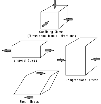
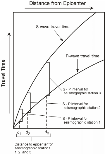
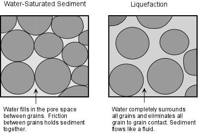
You can demonstrate this process to yourself next time your go the beach. Stand on the sand just after an incoming wave has passed. The sand will easily support your weight and you will not sink very deeply into the sand if you stand still. But, if you start to shake your body while standing on this wet sand, you will notice that the sand begins to flow as a result of liquefaction, and your feet will sink deeper into the sand.

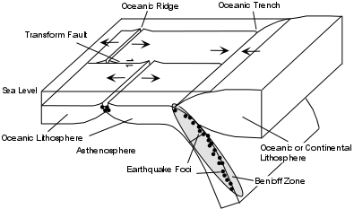
Aftershocks - Earthquakes can change the stress state in rocks near the hypocenter and this may induce numerous earthquakes that occur after the main earthquake.  These are almost always smaller earthquakes, but they can be numerous and last for many months after the main earthquake.  Aftershocks are particularly dangerous because that can cause further damage to already damaged structures and make it unsafe for rescue efforts to be pursued.

Tsunami - Tsunami are giant ocean waves that can rapidly travel across oceans. Earthquakes that occur along coastal areas can generate tsunami, which can cause damage thousands of kilometers away on the other side of the ocean.

Tsunami can be generated by anything that disturbs a body of water.   This includes earthquakes that cause vertical offset of the sea floor, volcanic eruptions into a body of water, landslides into a body of water, underwater explosions, and meteorite impacts.  

In general, the larger the earthquake, eruption, landslide, explosion or meteorite, the more likely it will be able to travel across an ocean.   Smaller events may, however cause a tsunami that affect areas in the vicinity of the triggering event.  

Tsunami waves have wavelengths and velocities much higher that wind driven ocean waves.  Velocities are on the order of several hundred km/hr, similar to a jet airplane.  They usually are more than one wave, that hit the coastline tens of minutes to hours apart.  Although wave heights are barely perceptible in the open ocean, the waves become amplified as the approach the shore and may build to several tens of meters.  Thus, when the come ashore, the can flood areas far away from the coast.  Often the trough of a tsunami wave arrives before the crest,  This produces a phenomenon called drawdown where the ocean recedes from the normal shoreline by as much as a kilometer.

Tsunami warning systems have been developed for the Pacific Ocean basin and, recently, the Indian Ocean where a tsunami killed over 250,000 people in 2004.  But, such warning systems depend on the ability to detect and forecast a tsunami after an earthquake occurs and may take several hours to come up with an accurate forecast of wave heights and travel time. 

Knowing something about these aspects of tsunami could save your life.  It suggests that

  1. If you are near the beach and feel an earthquake immediately get to higher ground.   Tsunami warnings require time and if you are near enough to the earthquake that generates a tsunami that you feel the earthquake, there may not be enough time for a warning to be sounded, nor will there be enough time to get out of the way once you see the wave approaching.

  2. If you are near the beach and see the ocean recede far offshore, immediately get to higher ground, as the receding ocean indicates that the trough of a tsunami wave has arrived and will be followed by the crest.

  3. If you survive the first wave of a tsunami, don't go back to the coast assuming the event is over.  Several waves are possible and any of them could be the largest of the waves.   Wait for authorities to issue an "all clear signal".

  4. Don't even consider "surfing the tsunami wave" or riding it out.  The waves are so powerful and last such a long time, that you would have little chance of surviving. 

Where do Earthquakes Occur


The distribution and frequency of earthquakes is referred to as seismicity. Most earthquakes occur along relatively narrow belts that coincide with plate boundaries (see figure 10.18 in your text).

This makes sense, since plate boundaries are zones along which lithospheric plates mover relative to one another. Earthquakes along these zones can be divided into shallow focus earthquakes that have focal depths less than about 70 km and deep focus earthquakes that have focal depths between 75 and 700 km. worldseis.gif (34522 bytes)


Earthquakes at Diverging Plate Boundaries

Diverging plate boundaries are zones where two plates move away from each other, such as at oceanic ridges. In such areas the lithosphere is in a state of tensional stress and thus normal faults and rift valleys occur. Earthquakes that occur along such boundaries show normal fault motion and tend to be shallow focus earthquakes, with focal depths less than about 20 km. Such shallow focal depths indicate that the brittle lithosphere must be relatively thin along these diverging plate boundaries. 

Earthquakes at Converging Plate Boundaries -

Convergent plate boundaries are boundaries where two plates run into each other. Thus, they tend to be zones where compressional stresses are active and thus reverse faults or thrust faults are common. There are two types of converging plate boundaries. (1) subduction boundaries, where oceanic lithosphere is pushed beneath either oceanic or continental lithosphere; and (2) collision boundaries where two plates with continental lithosphere collide.

  • Subduction boundaries -At subduction boundaries cold oceanic lithosphere is pushed back down into the mantle where two plates converge at an oceanic trench. Because the subducted lithosphere is cold, it remains brittle as it descends and thus can fracture under the compressional stress. When it fractures, it generates earthquakes that define a zone of earthquakes with increasing focal depths beneath the overriding plate. This zone of earthquakes is called the Benioff Zone. Focal depths of earthquakes in the Benioff Zone can reach down to 700 km.

  • Collision boundaries - At collisional boundaries two plates of continental lithosphere collide resulting in fold-thrust mountain belts. Earthquakes occur due to the thrust faulting and range in depth from shallow to about 200 km.

Earthquakes at Transform Fault Boundaries

Transform fault boundaries are plate boundaries where lithospheric plates slide past one another in a horizontal fashion. The San Andreas Fault of California is one of the longer transform fault boundaries known. Earthquakes along these boundaries show strike-slip motion on the faults and tend to be shallow focus earthquakes with depths usually less than about 50 km. 

Intraplate Earthquakes - These are earthquakes that occur in the stable portions of continents that are not near plate boundaries.  Many of them occur as a result of re-activation of ancient faults, although the causes of some intraplate earthquakes are not well understood.

  • Examples - New Madrid Region, Central U.S., Charleston South Carolina, Along St. Lawrence River - U.S. - Canada Border.

Earthquake Risk

The risk that an earthquake will occur close to where you live depends on whether or not tectonic activity that causes deformation is occurring within the crust of that area. For the U.S., the risk is greatest in the most tectonically active area, that is near the plate margin in the Western U.S. Here, the San Andreas Fault which forms the margin between the Pacific Plate and the North American Plate, is responsible for about 1 magnitude 8 or greater earthquake per century. Also in the western U.S. is the Basin and Range Province where extensional stresses in the crust have created many normal faults that are still active. Historically, large earthquakes have also occurred in the area of New Madrid, Missouri;and Charleston, South Carolina. (See figure 10.39 in your text). Why earthquakes occur in these other areas is not well understood. If earthquakes have occurred before, they are expected to occur again.

Long-Term Forecasting
Long-term forecasting is based mainly on the knowledge of when and where earthquakes have occurred in the past.  Thus, knowledge of present tectonic setting, historical records, and geological records are studied to determine locations and recurrence intervals of earthquakes.  Two methods of earthquake forecasting are being employed - paleoseismology and seismic gaps.

  • Paleoseismology - the study of prehistoric earthquakes.  Through study of the offsets in sedimentary layers near fault zones, it is often possible to determine recurrence intervals of major earthquakes prior to historical records.  If it is determined that earthquakes have recurrence intervals of say 1 every 100 years, and there are no records of earthquakes in the last 100 years, then a long-term forecast can be made and efforts can be undertaken to reduce seismic risk.

  • Seismic gaps - A seismic gap is a zone along a tectonically active area where no earthquakes have occurred recently, but it is known that elastic strain is building in the rocks.  If  a seismic gap can be identified, then it might be an area expected to have a large earthquake in the near future.

Short-Term Prediction

  • Short-term predication involves monitoring of processes that occur in the vicinity of earthquake prone faults for activity that signify a coming earthquake.  
  • Anomalous events or processes that may precede an earthquake are called precursor events and might signal a coming earthquake.

  • Despite the array of possible precursor events that are possible to monitor, successful short-term earthquake prediction has so far been difficult to obtain.   This is likely because:

    • the processes that cause earthquakes occur deep beneath the surface and are difficult to monitor.
    • earthquakes in different regions or along different faults all behave differently, thus no consistent patterns have so far been recognized

Among the precursor events that may be important are the following:

  • Ground Uplift and Tilting  - Measurements taken in the vicinity of active faults sometimes show that prior to an earthquake the ground is uplifted or tilts due to the swelling of rocks caused by strain building on the fault.  This may lead to the formation of numerous small cracks (called microcracks).  This cracking in the rocks may lead to small earthquakes called foreshocks.
  • Foreshocks - Prior to a 1975 earthquake in China, the observation of numerous foreshocks led to successful prediction of an earthquake and evacuation of the city of the Haicheng.  The magnitude 7.3 earthquake that occurred, destroyed half of the city of about 100 million inhabitants, but resulted in only a few hundred deaths because of the successful evacuation. 
  • Water Level in Wells - As rocks become strained in the vicinity of a fault, changes in pressure of the groundwater (water existing in the pore spaces and fractures in rocks) occur.  This may force the groundwater to move to higher or lower elevations, causing changes in the water levels in wells.
  • Emission of Radon Gas - Radon is an inert gas that is produced by the radioactive decay of uranium and other elements in rocks.  Because Radon is inert, it does not combine with other elements to form compounds, and thus remains in a crystal structure until some event forces it out.  Deformation resulting from strain may force the Radon out and lead to emissions of Radon that show up in well water.  The newly formed microcracks discussed above could serve as pathways for the Radon to escape into groundwater.  Increases in the amount of radon emissions have been reported prior to some earthquakes
  • Strange Animal Behavior - Prior to a magnitude 7.4 earthquake in Tanjin, China, zookeepers reported unusual animal behavior.  Snakes refusing to go into their holes, swans refusing to go near water, pandas screaming, etc.  This was the first systematic study of this phenomenon prior to an earthquake.  Although other attempts have been made to repeat a prediction based on animal behavior, there have been no other successful predictions.

Controlling Earthquakes

Although no attempts have yet been made to control earthquakes, earthquakes have been known to be induced by human interaction with the Earth.  This suggests that in the future earthquake control may be possible. 

Examples of human induced earthquakes

  • For ten years after construction of the Hoover Dam in Nevada blocking the Colorado River to produce Lake Mead, over 600 earthquakes occurred, one with magnitude of 5 and 2 with magnitudes of 4.
  • In the late 1960s toxic waste injected into hazardous waste disposal wells at Rocky Flats, near Denver apparently caused earthquakes to occur in a previously earthquake quiet area.  The focal depths of the quakes ranged between 4 and 8 km, just below the 3.8 km-deep wells.
  • Nuclear testing in Nevada set off thousands of aftershocks after the explosion of a 6.3 magnitude equivalent underground nuclear test.  The largest aftershocks were about magnitude 5. 

In the first two examples the increased seismicity was apparently due to increasing fluid pressure in the rocks which resulted in re-activating older faults by increasing strain. 

The problem, however, is that of the energy involved.  Remember that for every increase in earthquake magnitude there is about a 30 fold increase in the amount of energy released.  Thus, in order to release the same amount of energy as a magnitude 8 earthquake, 30 magnitude 7 earthquakes would be required.  Since magnitude 7 earthquakes are still very destructive, we might consider generating smaller earthquakes.   If we say that a magnitude 4 earthquake might be acceptable, how many magnitude 4 earthquakes are required to release the same amount of energy as a magnitude 8 earthquake?   Answer 30 x 30 x 30 x 30 =810,000!  Still, in the future it may be possible to control earthquakes either with explosions to gradually reduce the stress or by pumping fluids into the ground.

Mitigating for Earthquake Hazards

Many seismologists have said that "earthquakes don't kill people, buildings do". This is because most deaths from earthquakes are caused by buildings or other human construction falling down during an earthquake. Earthquakes located in isolated areas far from human population rarely cause any deaths. Thus, in earthquake prone areas like California, there are strict building codes requiring the design and construction of buildings and other structures that will withstand a large earthquake. While this program is not always completely successful, one fact stands out to prove its effectiveness. In 1986 an earthquake near San Francisco, California with a Richter Magnitude of 7.1 killed about 40 people. Most were killed when a double decked freeway collapsed. About 10 months later, an earthquake with magnitude 6.9 occurred in the Armenia, where no earthquake proof building codes existed. The death toll in the latter earthquake was about 25,000!

Another contrast occurred in 2010. On January 12, an earthquake of Moment Magnitude 7.0 occurred in Haiti.  The country is one of the poorest on earth, had no earthquake resistant building codes, and most of the construction was poorly reinforced concrete.   The destruction was massive with an estimated 250,000 deaths.  On February 27, a Moment Magnitude 8.8 earthquake occurred in Chile, a country where earthquake resistant building codes were enforced.  The death toll from this larger earthquake was about 520, again, proving the effectiveness of building codes.

How Seismic Waves Help Understand Earth's Internal Structure

Much of what we know about the interior of the Earth comes from knowledge of seismic wave velocities and their variation with depth in the Earth. Recall that body wave velocities are as follows:

Where K = incompressibility
μ = rigidity
ρ = density

If the properties of the earth, i.e. K,μ, and ρwhere the same throughout, then Vp and Vs would be constant throughout the Earth and seismic waves would travel along straight line paths through the Earth. We know however that density must change with depth in the Earth, because the density of the Earth is 5,200 kg/cubic meter and density of crustal rocks is about 2,500 kg/cubic meter. If the density were the only property to change, then we could make estimates of the density, and predict the arrival times or velocities of seismic waves at any point away from an earthquake. Observations do not follow the predictions, so, something else must be happening. In fact we know that K, μ, and ρ change due to changing temperatures, pressures and compositions of material. The job of seismology is, therefore, to use the observed seismic wave velocities to determine how K, μ, and ρ change with depth in the Earth, and then infer how pressure , temperature, and composition change with depth in the Earth. In other words to tell us something about the internal structure of the Earth.

Reflection and Refraction of Seismic Waves

If composition (or physical properties) change abruptly at some interface, then seismic wave will both reflect off the interface and refract (or bend) as they pass through the interface. Two cases of wave refraction can be recognized.

  1. If the seismic wave velocity in the rock above an interface is less than the seismic wave velocity in the rock below the interface, the waves will be refracted or bent upward relative to their original path.

  1. If the seismic wave velocity decreases when passing into the rock below the interface, the waves will be refracted down relative to their original path.
  • If the seismic wave velocities gradually increase with depth in the Earth, the waves will continually be refracted along curved paths that curve back toward the Earth's surface.

One of the earliest discoveries of seismology was a discontinuity at a depth of 2900 km where the velocity of P-waves suddenly decreases. This boundary is the boundary between the mantle and the core and was discovered because of a zone on the opposite side of the Earth from an earthquake focus receives no direct P-waves because the P-waves are refracted inward as a result of the sudden decrease in velocity at the boundary. 

This zone is called a P-wave shadow zone.

This discovery was followed by the discovery of an S-wave shadow zone. The S-wave shadow zone occurs because no S-waves reach the area on the opposite side of the Earth from the focus. Since no direct S-waves arrive in this zone, it implies that no S-waves pass through the core. This further implies the velocity of S-wave in the core is 0. In liquids μ = 0, so S-wave velocity is also equal to 0. From this it is deduced that the core, or at least part of the core is in the liquid state, since no S-waves are transmitted through liquids.

Thus, the S-wave shadow zone is best explained by a liquid outer core.

Seismic Wave Velocities in the Earth

Over the years seismologists have collected data on how seismic wave velocities vary with depth in the Earth. Distinct boundaries, called discontinuities are observed when there is sudden change in physical properties or chemical composition of the Earth. From these discontinuities, we can deduce something about the nature of the various layers in the Earth. As we discussed way back at the beginning of the course, we can look at the Earth in terms of layers of differing chemical composition, and layers of differing physical properties.


  • Layers of Differing Composition - The Crust - Mohorovicic discovered boundary the boundary between crust and mantle, thus it is named the Mohorovicic Discontinuity or Moho, for short. The composition of the crust can be determined from seismic waves by comparing seismic wave velocities measured on rocks in the laboratory with seismic wave velocities observed in the crust. Then from travel times of waves on many earthquakes and from many seismic stations, the thickness and composition of the crust can be inferred.

    • In the ocean basins crust is about 8 to 10 km thick, and has a composition that is basaltic.

    • Continental crust varies between 20 and 60 km thick. The thickest continental crust occurs beneath mountain ranges and the thinnest beneath lowlands. The composition of continental crust varies from granitic near the top to gabbroic near the Moho. 

    • The Mantle - Seismic wave velocities increase abruptly at the Moho. In the mantle wave velocities are consistent with a rock composition of peridotite which consists of olivine, pyroxene, and garnet.

.

    • The Core - At a depth of 2900 Km P-wave velocities suddenly decrease and S-wave velocities go to zero. This is the top of the outer core. As discussed above, the outer core must be liquid since S-wave velocities are 0. At a depth of about 4800 km the sudden increase in P-wave velocities indicate a solid inner core. The core appears to have a composition consistent with mostly Iron with small amounts of Nickel.


  • Layers of Different Physical Properties
    • At a depth of about 100 km there is a sudden decrease in both P and S-wave velocities. This boundary marks the base of the lithosphere and the top of the asthenosphere. The lithosphere is composed of both crust and part of the upper mantle. It is a brittle layer that makes up the plates in plate tectonics, and appears to float and move around on top of the more ductile asthenosphere.
    • At the top of the asthenosphere is a zone where both P- and S-wave velocities are low. This zone is called the Low-Velocity Zone (LVZ). It is thought that the low velocities of seismic waves in this zone are caused by temperatures approaching the partial melting temperature of the mantle, causing the mantle in this zone to behave in a very ductile manner.
    • At a depth of 400 km there is an abrupt increase in the velocities of seismic waves, thus this boundary is known as the 400 - Km Discontinuity. Experiments on mantle rocks indicate that this represents a temperature and pressure where there is a polymorphic phase transition, involving a change in the crystal structure of Olivine, one of the most abundant minerals in the mantle.
    • Another abrupt increase in seismic wave velocities occurs at a depth of 670 km. It is uncertain whether this discontinuity, known as the 670 Km Discontinuity, is the result of a polymorphic phase transition involving other mantle minerals or a compositional change in the mantle, or both. 

Seismic Tomography

Most of you are aware of the techniques used in modern medicine to see inside the human body.   These are things like CT scans, ultrasound, and X-rays.  All them use waves, either sound waves or electromagnetic waves, that penetrate the body and reflect and refract from and through body parts that have different physical properties.   The techniques require a source of waves with enough energy to penetrate, the ability to generate these waves continuously in places that will penetrate the area of interest, and the ability to detect the resulting reflected and refracted waves when they emerge.  Similar imaging can be done for the earth, but it is much more complicated. Seismic waves from a large earthquake can penetrate the earth, but each earthquake is a single point source for the waves.   Seismometers can detect the waves when they emerge, but seismometers are not placed everywhere on the earth's surface.   Nevertheless, if data is collected over many years, the information can be used to produce an image of the interior of the earth.   Such images are sill pretty primitive, but allow us to see areas that are hotter than their surroundings, where seismic wave velocities are slower and areas that are cooler than their surroundings where velocities are higher.  Such images from seismic tomography are shown on pages 368-369 of your text.


Examples of questions on this material that could be asked on an exam
  1. Define the following terms (a), stress (b) confining stress, (c) differential stress, (d) tensional stress (e) compressional stress, (e) strain (f) liquifaction, (g) fault creep, (h) Benioff Zone.

  2. What are the three stages of deformation that all materials go through as stress is increased?

  3. What is the difference between a brittle material and a ductile material?

  4. Explain the following types of faults: (a) normal fault, (b) reverse fault, (c) thrust fault, (d) strike-slip fault, and (e) transform fault.

  5. Explain the elastic rebound theory on the cause earthquakes.

  6. What is the difference between the epicenter and the focus of an earthquake.

  7. What are seismic waves and what is the difference between a P-wave, an S-wave and a Surface waves?

  8. For each increase of magnitude by a factor of 1, how much more energy is released?

  9. What is the difference between Richter magnitude and Moment magnitude and which of these scales is a more accurate measure of the energy released by large earthquakes?

  10. What is the difference between the magnitude scale and the Modified Mercalli Scale?

  11. How does ground shaking during an earthquake depend on such things as distance from the epicenter and type of bedrock?

  12. Why are fires common during earthquakes?

  13. What is the difference between tsunami and wind-driven ocean waves?

  14. What steps can you take to avoid being killed by a tsunami?

  15. What are the concepts of paleosiesmology and seismic gaps, and what information can studies in these areas provide?

  16. Why has short-term earthquake prediction been unsuccessful?

  17. What kinds of precursor events have been explored in an attempt to predict earthquakes?

  18. Is it possible for humans to induce earthquakes?

  19. In what tectonic settings do earthquakes occur?  Explain why earthquakes occur in each of these settings.

  20. What are P-wave and S-wave shadow zones and what do they tell us about the interior of the earth?

Return to EENS 1110 Page