- Cover about 71% of the surface of the Earth.
- The greatest ocean depth of 11,035 m occurs in the Mariana Trench
- Have an average depth of 3,800 m.
- Have a present volume of about 1.35 billion cubic kilometers, but the volume fluctuates
with the growth and melting of glacial ice.
- Help to regulate transfer of mass and energy between biosphere, lithosphere and atmosphere.
- 40 to 50% of the world's population live within 100 km of a coast.
The Oceans exist because of differences in lithosphere as reflected by isostasy.
Continental lithosphere “floats higher” on the asthenosphere because the embedded continental crust has a lower density.
Oceanic lithosphere “floats deeper” in the asthenosphere because is it is denser. The ocean basins collect water because they are “lower.”
The Ocean Floor
The ocean floor was very much unknown until the late 1800s when the first scientific expeditions were undertaken. Our knowledge greatly expanded during and after World War II. Bathymetry was mapped, and oceanic ridges and trenches were discovered, This was accomplished through sonar soundings of ocean depth and submarine exploration of the deep oceans. Later drilling of the sea floor for the collection of samples was undertaken. It was a better understanding of the ocean floor which led to the theory of Plate Tectonics.
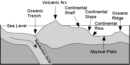
The most important bathymetric features of the sea floor are
- Continental Shelf, Slope, and Rise
- Abyssal Plains
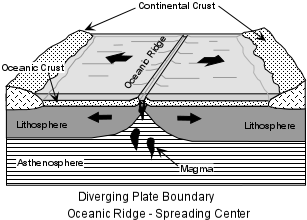
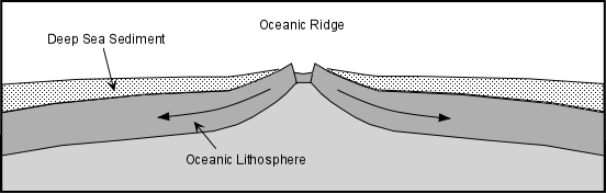
- Oceanic ridges
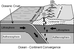
- Oceanic Trenches
The bathymetry of the sea floor reflects tectonics. The Continental shelf is underlain by thinning continental crust. The continental slope and rise are transitional between crustal types, and the abyssal plain is underlain by mafic oceanic crust. Oceanic ridges are diverging plate boundaries where new oceanic lithosphere is formed and oceanic trenches are converging plate boundaries where oceanic lithosphere is subducted.
Because oceanic lithosphere may get subducted, the age of the ocean basins is relatively young. The oldest oceanic crust occurs farthest away from a ridge. In the Atlantic Ocean, the oldest oceanic crust occurs next to the North American and African continents and is Jurassic in age (see figure 4.9 in your text). In the Pacific Ocean, the oldest crust is also Jurassic in age, and occurs off the coast of Japan.
Because the oceanic ridges are areas of young crust, there is very little sediment accumulation on the ridges. Sediment thickness increases in both directions away of the ridge, and is thickest where the oceanic crust is the oldest.
Sediment on the abyssal plain is mainly fined grained sediment (clay size) that was input into the oceans by streams and winds from the continents. The accumulation of the remains of silica secreting planktonic organisms like radiolaria and diatoms, has produced chert and the accumulation of the remains of foraminifera has produced biogenic limestones.
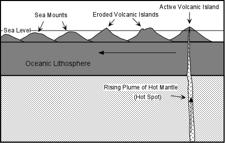
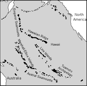
Besides the oceanic ridges, oceanic islands and seamounts occur in the ocean basins. These are mostly volcanic islands that were formed above hot spots. The volcanoes formed over the hot spot and after the volcano goes extinct, it is eroded to sea level. Continued cooling and subsidence submerges the island to form seamounts (also called guyots).
Where the continents meet the oceans, the continental margins are characterized as being of one of two types: Passive or Active.